Mount Everest is on the border between Nepal and China’s Tibet region. The top of the mountain is the exact border and belongs to both countries.
We frequently receive the question, "Where is Mount Everest located Nepal or China?" as a Nepal-based travel company with years of experience planning Everest treks. Many travelers are surprised by the response. Even though Everest is located between the two countries, the majority of expeditions and treks begin in Nepal, which is the location of the fabled Everest Base Camp Trek.
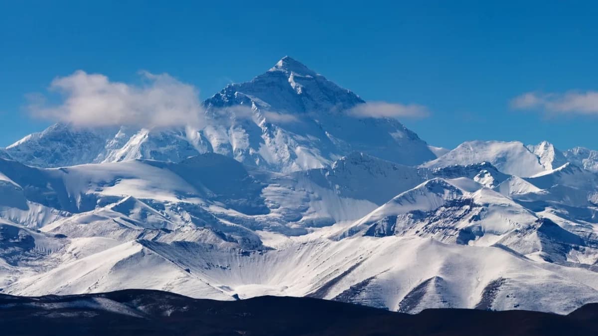
Everest is the tallest mountain in the world at 8,848 meters (29,029 feet). Everest is officially recognized as standing at 8,848.86 m (29,031.7 ft) according to a joint 2020 survey by Nepal and China. This measurement includes snow and ice, while the rock height alone is about 8,844.43 m. Its top is exactly on this line, with the northern slopes rising in Tibet and the southern slopes falling into the Solukhumbu District of Nepal.
Because Everest sits on the border, it shows how Nepal and China share the mountain peacefully. Climbers can reach Everest from both sides, making it a special treasure for both countries.
Quick Facts About Mount Everest’s Location
|
Fact |
Detail |
|
Country Border |
Nepal & China (Tibet Autonomous Region) |
|
Coordinates |
27.9881° N, 86.9250° E |
|
Elevation |
8,848.86 m (29,032 ft |
|
Rock Height (China) |
8,844.43 m (29,017 ft) |
|
Annual Uplift |
A few millimeters per year (due to tectonic movement) |
|
Summit Ownership |
Shared by Nepal and China |
|
South Base Camp |
Nepal (Sagarmatha National Park) |
|
North Base Camp |
Tibet (Tingri County) |
|
UNESCO Status |
Sagarmatha NP was listed in 1979 |
|
Popular Route |
South Col (Nepal side) |
|
Local Names |
Sagarmatha (Nepal), Chomolungma (Tibet) |
|
Official Border Agreement |
Signed in 1961 between Nepal and China |
These quick Everest location facts help travelers clearly understand where Mount Everest is located and why both Nepal and China (Tibet) play key roles in protecting this natural wonder.
So, Where Exactly Is Mount Everest Located?
Mount Everest is located at 27.9881° N latitude and 86.9250° E longitude, right on the border between Nepal and China. According to the Himalayan Database, the precise coordinates of the summit are 27°59′17″ N, 86°55′31″ E (equivalent to 27.9881° N, 86.9250° E).
On the Nepal side, it is part of Sagarmatha National Park in the Solukhumbu District. This park is a beautiful protected area with Sherpa villages and many kinds of wild animals. On the Chinese side, Everest stands in Tingri County, giving amazing views from another side of the mountain.
Because of this unusual location, climbers are actually standing on two nations at once when they reach the summit. The precise boundary between these two Asian countries is the peak itself.
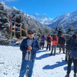
When you visit Mount Everest from the Nepal side, you enter the heart of the Sagarmatha National Park, one of the most beautiful trekking regions in the world. From here, you can join a guided Everest Base Camp trek and experience breathtaking views that have made Nepal the ultimate destination for Everest explorers.
Is Mount Everest in Nepal or China? Understanding Both Sides
Many travelers wonder which country Mount Everest is in. The international boundary runs exactly across the summit, meaning no single country owns it entirely. Nepal governs the southern slope, and China (Tibet) the northern. Let’s look at what you can find on each side.
So, when people ask, “Where is Mt. Everest located Nepal or China? the correct answer is both. The border runs precisely across the summit.
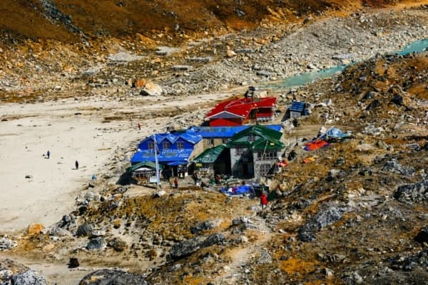
The Nepal Side – Sagarmatha National Park
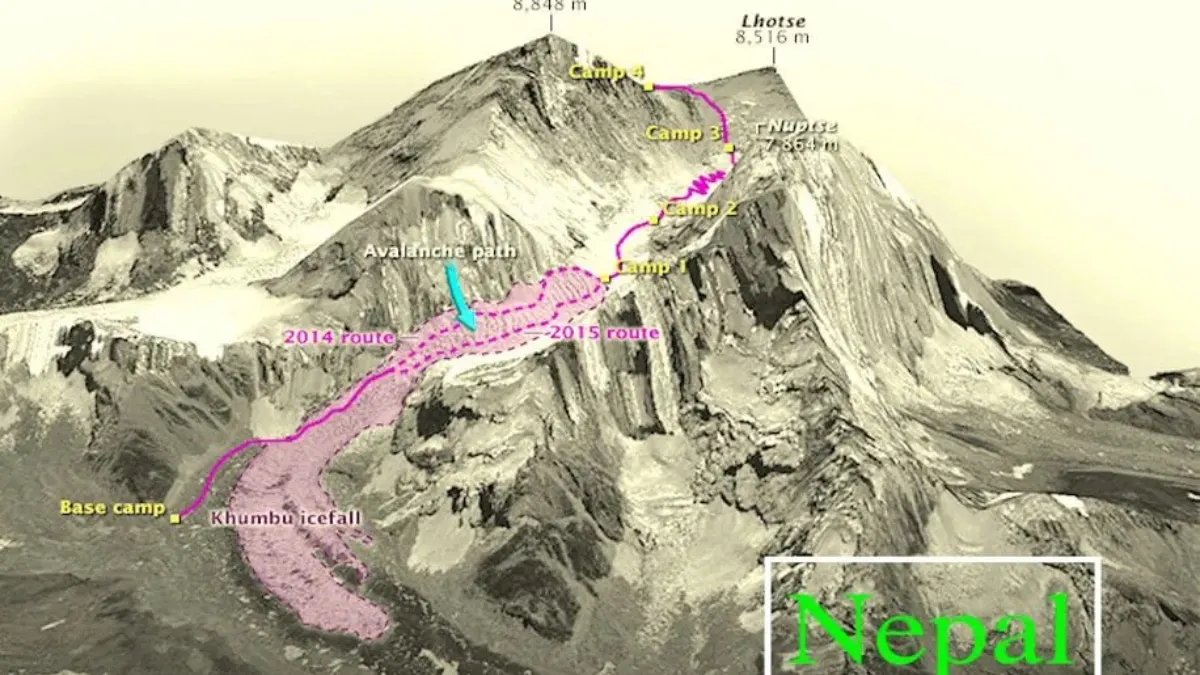
The most well-liked trekking experience in the world is offered by Nepal's southern face of Mount Everest. This area, which is part of the Solukhumbu District, has:
- Easy Access for Trekkers: Most adventurers fly into Lukla Airport, then trek through charming villages like Namche Bazaar, Tengboche, and Dingboche before reaching South Base Camp, Nepal. The journey takes about 12-14 days round-trip.
- Rich Sherpa Culture: The Khumbu region is home to the famed Sherpa people, whose kindness and mountaineering expertise have made Everest expeditions possible. Discover genuine Himalayan culture, tour historic monasteries, and sample regional specialties like Sherpa stew and dal bhat.
- UNESCO Heritage Status: Sagarmatha National Park became a UNESCO World Heritage Site in 1979 because it is very important for nature and has many different plants and animals. When you trek there, you might see animals like Himalayan tahr, red pandas, and bright-colored pheasants.
- Well-Developed Infrastructure: Teahouses line the entire route, offering comfortable accommodation, hot meals, and WiFi at most stops. This makes the Nepal side perfect for trekkers of all experience levels.
- Permits needed: Sagarmatha National Park Entry Permit (NPR 3,000) + Khumbu Pasang Lhamu Permit (NPR 2,000).
Trekking on the Nepal side is not just about reaching the base camp, it’s about embracing Sherpa hospitality, Buddhist culture, and the serene beauty of the Khumbu region. Our Everest trekking packages from Nepal offer customized routes to match your fitness and comfort level.
Learn more about our Everest Base Camp Trek packages for every fitness level.
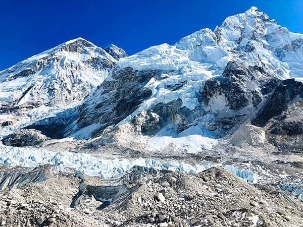
Did You Know? Sagarmatha National Park is also home to Kala Patthar, one of the best viewpoints for Mount Everest. From here, you can see the full south face of the mountain.
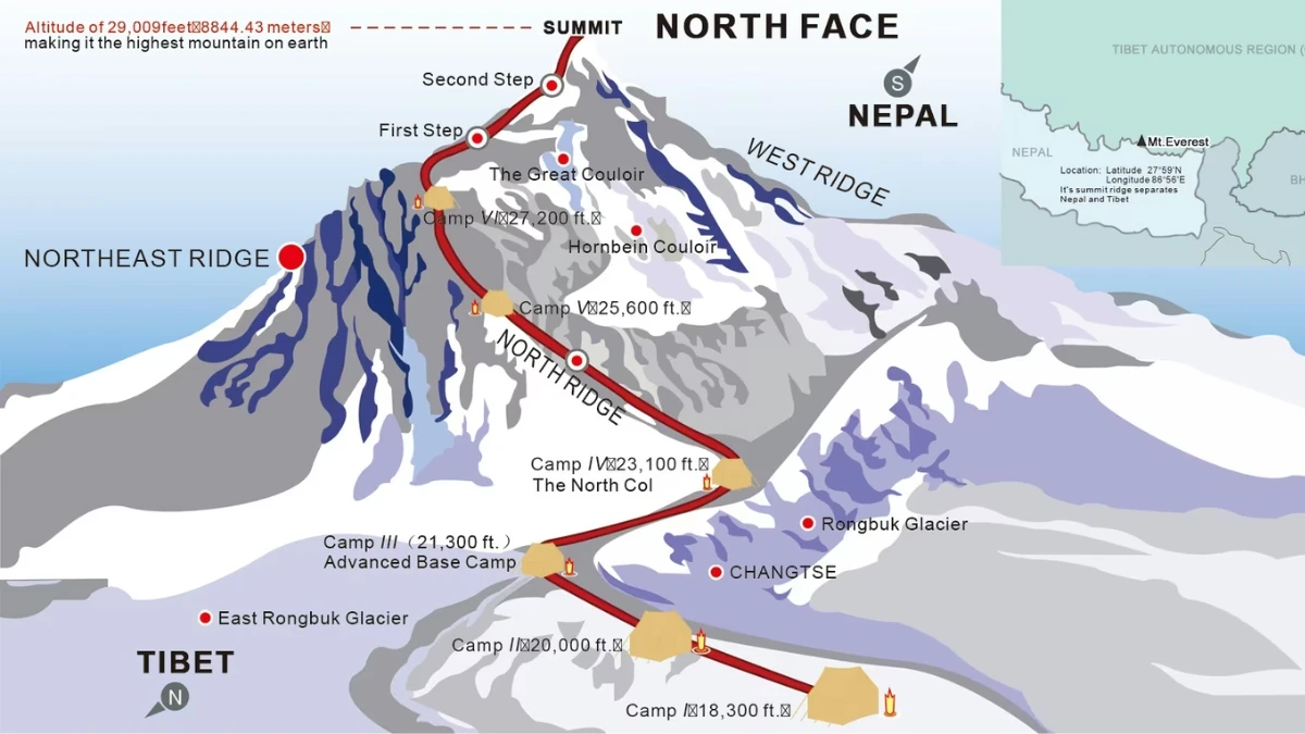
The China Side – Tibet Autonomous Region
Mount Everest in Tibet offers a completely different experience. Known locally as Chomolungma, meaning "Goddess Mother of Mountains," the northern face of Everest presents unique advantages:
- Road Access: In Nepal, you need to hike to reach Everest, but in Tibet, you can drive to the North Base Camp from Lhasa. The drive is about 700 kilometers across the beautiful Tibetan plateau. This is easier for people who cannot walk long distances.
- Fewer Crowds: Fewer people visit the Tibet side because it is far away. You must obtain a Tibet Travel Permit, an Alien’s Travel Permit, and a separate Everest Base Camp permit via a registered Chinese operator. Independent travel isn’t allowed.
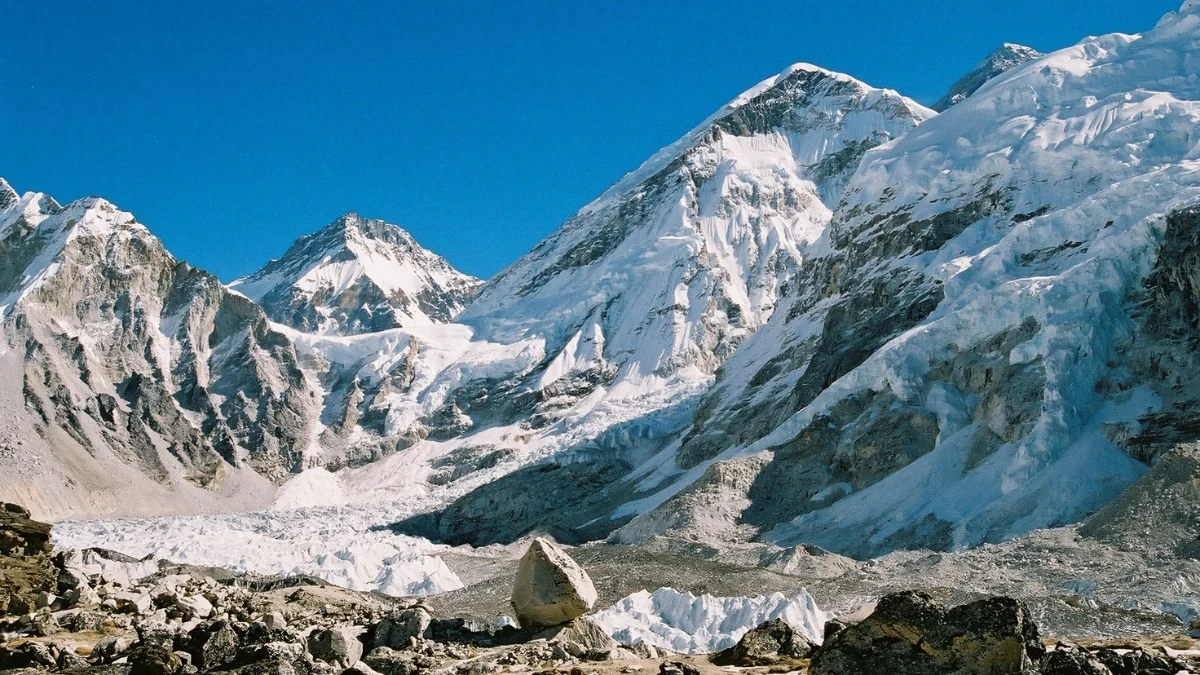
- The North Base Camp lies at approximately 5,200 m (17,060 ft) in Tingri County.This means it is quieter and the views are very clean.
- Panoramic Summit Views: North Base Camp is 5,150 meters high and gives clear, wide views of Everest’s north side. Many photographers like this place to take pictures of the mountain’s full size.
- Cultural Significance: Tibetan Buddhists have worshipped Chomolungma for hundreds of years. You can see prayer flags, chaupa, and monasteries that show their strong spiritual connection to the mountain.
While few visit the Tibet side, it provides a unique perspective of the Mount Everest location from China, showcasing the northern ridges and high-altitude landscapes that define Tibet’s spiritual side.
Fact: The Tibetan government occasionally restricts access to the North Base Camp for environmental protection. Always check travel advisories before planning your visit.
Which Country Owns Mount Everest?
Both Nepal and China share ownership of Mount Everest because the peak forms their international boundary. Neither country owns it exclusively. While both Nepal and China administer their respective sides, climbers must apply for permits from the country through which they ascend.
In the 1960s, Nepal and China officially agreed on the border between their countries, making the top of Mount Everest the dividing line. This means the summit belongs to both nations.
China and Nepal collaborated in 2020 to determine Mount Everest's precise height. Both of them claim that it is 8,848.86 meters (29,031.7 feet) high. This cooperation endeavor demonstrates the two nations' respect for each other and their desire to give accurate information about the highest mountain in the world.
This shared ownership adds to the cultural richness of Mount Everest’s geography. When travelers trek from Nepal, they not only experience the mountain’s natural beauty but also learn how two nations coexist harmoniously along the Everest border between Nepal and China.
Besides sharing the mountain’s peak, the two countries also work closely to protect the environment around Everest. The mountain and its natural surroundings do not follow political borders, so both Nepal and China understand the need to take care of it together.
They work together on major concerns including combating climate change, handling the trash that climbers leave behind, and ensuring that climbing is safe. Together, they hope to celebrate the common natural beauty of Mount Everest while maintaining its cleanliness and safety for future generations.
Everest Border Between Nepal and China
The international boundary passes directly through Everest's summit, creating a fascinating geopolitical situation. Each country has its own name for the mountain Sagarmatha in Nepal and Chomolungma in Tibet, reflecting their distinct cultural connections to this giant.
|
Side |
Country |
Region |
Known For |
Base Camp |
|
South |
Nepal |
Sagarmatha NP |
Trekking routes, Sherpa culture |
South Base Camp (5,364m) |
|
North |
China |
Tibet Autonomous Region |
Road access, panoramic views |
North Base Camp (5,200m) |
Note: The international border was formally defined by both nations in a 1961 boundary agreement.”
If you’re starting from Nepal, the Everest Base Camp Trek provides the best access to this historic border region. Standing at the base of the world’s highest peak, travelers can literally gaze into two countries at once.
This border arrangement means that climbing permits must be obtained from the country whose route you plan to use. Nepal issues permits through the Department of Tourism, while China requires permits through the Tibet Tourism Bureau.
Fact: Each country issues its own climbing permits Nepal through the Department of Tourism and China through the Tibet Mountaineering Association.
Why the Nepal Side of Everest Is More Popular?
The Nepal side dominates Everest tourism for several compelling reasons that matter to trekkers:
- Superior Trekking Infrastructure: Decades of tourism development have created a reliable network of lodges, rescue services, and guided expedition companies. You'll never feel alone or unsupported on the trail.
- The Legendary Lukla Flight: While notorious for its short runway and dramatic mountain backdrop, the flight from Kathmandu to Lukla has become an iconic part of the Everest experience. It gets you to the trailhead in just 30-45 minutes.
- The Khumbu Experience: Trekking through villages like Namche Bazaar, Tengboche, and Gorak Shep offers cultural immersion you won't find on the Tibet side. The famous Everest Base Camp Trek has become a bucket-list adventure for good reason.
- Sherpa Hospitality: Sherpa guides and lodge owners welcome trekkers like family. They share stories, keep you safe, and help you make great memories during your trek.
- Better Acclimatization: On the Nepal side, the altitude rises slowly. Trekkers rest in villages along the way, which helps their bodies get used to the thin air and lowers the chance of altitude sickness.
Note: Around 90% of Everest expeditions begin from Nepal’s southern route due to its better acclimatization profile.
This is why most Everest expeditions, including the historic 1953 climb by Sir Edmund Hillary and Tenzing Norgay, began from Nepal.
Are You Prepared to Visit Mt. Everest from Nepal? Join hundreds of explorers with Nepal Gateway Trekking who have realized their Himalayan ambitions when you reserve your Everest Base Camp Trek with us.
What About the Tibet Side of Mount Everest?
The North Base Camp Tibet route offers advantages for specific types of travelers:
- Vehicle Access: If you have time or physical limitations, you can avoid the 12-day hike by driving to North Base Camp. It might take a lot less time to get to base camp. A 700-kilometer drive from Lhasa, via Gyantse and Shigatse, leads to Tibet's base camp. The view of the North Face is unhindered despite the colder and windier weather.
- Permit Requirements: You'll need a Tibet Travel Permit, an Alien's Travel Permit, and a climbing permit if attempting the summit. These must be arranged through authorized Chinese tour operators; independent travel isn't allowed in Tibet.
- Cultural Experience: The trip passes through places like Shigatse and Tingri as it traverses the enormous Tibetan plateau. You will go to the tallest monastery in the world, Rongbuk Monastery, which offers breathtaking views of Everest.
- Weather Challenges: The Tibet side faces harsher weather conditions and stronger winds than Nepal. The higher altitude of the approach (starting around 4,000 meters) means less time for acclimatization.
- Cost Considerations: Tibet-side expeditions typically cost more due to permit fees, mandatory guide requirements, and transportation logistics.
Despite the challenges, many photographers and adventure seekers still choose the Everest North Base Camp tour in Tibet for its dramatic views. However, for most travelers, trekking Mount Everest from Nepal remains the most fulfilling journey.
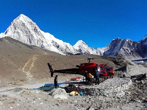
If you’re planning your adventure, the Everest helicopter day tour is a popular modern option for those seeking both comfort and adventure.
How High Is Mount Everest and Where Exactly Is Its Peak?
In 2020, following years of discussion, Nepal and China officially declared the official height to be 8,848.86 meters (29,032 feet) above sea level. Previous differences between the two countries were addressed by this measurement.
The peak itself is a single point; there aren't separate summits for each country. When climbers "summit Everest," they reach this exact spot where the international border passes through.
Interestingly, tectonic movements continue to push the Himalayas higher, meaning Everest grows. Scientists estimate the Himalayas are rising by a few millimeters per year due to tectonic plate movement. The height of 8,848.86 m includes snow and ice, while the rock height alone is around 8,844.43 m.
Climate change also affects snow and ice depth at the summit, which is why periodic remeasurements are necessary for accuracy.
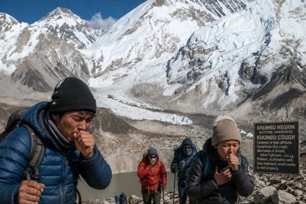
Because the summit is located in the so-called "death zone," where oxygen levels are only one-third of sea level, breathing becomes difficult and the amount of time climbers can safely stay at the top is limited.
Map View: Visualizing Mount Everest’s Location
On the Nepal side, the map shows the South Base Camp at 5,364 meters (17,598 feet). This is where most climbers and trekkers start their journey to Mount Everest. The trail goes through beautiful Sherpa villages in the Khumbu Valley. Places like Namche Bazaar and Kala Patthar are well-known stops offering great views of Everest’s south side.
On the Chinese side, the North Base Camp is around 5,200 meters (17,060 feet) in Tibet’s Tingri County. This route is less crowded and more controlled. It gives unique views of Everest’s north face, but has tougher weather and higher altitude challenges.
Both base camps are important starting points on opposite sides of Mount Everest.
Why Many Believe Everest Is Only in Nepal?
Several factors create the misconception that Everest belongs exclusively to Nepal:
- Dominance in Tourism Marketing: Nepal's tourism sector has successfully positioned itself as "the home of Everest." From international campaigns to airport ads, the phrase "Nepal: Naturally Nepal" and pictures of the mountain may be found everywhere.
- Trekking Popularity: The majority of Everest articles, documentaries, and social media posts highlight the southern route, which creates a perspective bias because the Nepal side is home to significantly more trekkers and climbers. Less than 2,000 hikers visit Tibet's Everest side each year, whereas about 35,000 trekkers visit Nepal's Everest region.
- Limited China-Side Access: Strict permit requirements and occasional closures of the Tibet side for environmental or political reasons mean fewer people experience or discuss the northern route.
- Media Influence: Famous films like "Everest" (2015) and countless documentaries focus on South Base Camp, Sherpa culture, and the Nepal experience, reinforcing the Nepal association in popular culture.
- Sir Edmund Hillary's Legacy: The first confirmed summit in 1953 by Edmund Hillary and Tenzing Norgay began from the Nepal side, cementing its place in mountaineering history.
Final Thoughts: A Mountain Shared by Two Nations
Mount Everest is a special mountain that belongs to both Nepal and China. It shows how nature can go beyond countries and borders. The mountain is impressive, and its importance grows because it is shared by two nations.
You can hike to the South Base Camp in Nepal, drive to the North Base Camp in Tibet, or just enjoy looking at Everest from far away. Whatever you do, always respect the mountain and the cultures of both Nepal and China.The Sherpa people of Nepal and the Tibetan communities of China have lived in harmony with Chomolungma/Sagarmatha for generations, and we as visitors must honor their traditions and protect this fragile environment.
Final Tip: Whether you trek from Nepal or visit Tibet, always follow Leave No Trace principles respect local cultures, minimize waste, and travel responsibly.
Whether you explore the Everest Base Camp Trek in Nepal or view the North Face from Tibet, you’ll witness why Mount Everest is more than just a mountain. It’s a global symbol of peace, endurance, and natural wonder.
Ready to Experience Everest, the Roof of the World? Whether you dream of trekking to Everest Base Camp in Nepal or visiting the North Base Camp in Tibet, we’ll help you get there safely and confidently.
Book your Everest adventure today with our local Sherpa guides, expert-led, eco-friendly, and unforgettable. Contact Nepal Gateway Trekking Today!
FAQs About Mount Everest’s Location
Is Mount Everest completely in Nepal?
No, Mount Everest is not completely in Nepal. It lies on the border between Nepal and China (Tibet), with the summit marking the exact international dividing line between the two countries.
What is Mount Everest called in Nepal and Tibet?
In Nepal, Mount Everest is known as Sagarmatha, meaning "forehead of the sky." In Tibet (China), it's called Chomolungma, which translates to "Goddess Mother of Mountains."
Which side of Mount Everest is easier to climb?
The Nepal side (South Col route) is generally considered more accessible and popular among climbers and trekkers. It offers better infrastructure, gradual acclimatization, and more rescue support than the Tibet side.
Can you visit Mount Everest from both Nepal and China?
Yes, you can visit Mount Everest from both Nepal and China. Nepal offers trekking to South Base Camp through Sagarmatha National Park, while Tibet allows road access to North Base Camp with proper permits.
Who owns Mount Everest’s summit?
Both Nepal and China share ownership of Mount Everest's summit. The peak is divided exactly by their international border, making it a shared natural treasure between the two nations.
Is it better to visit Mount Everest from Nepal or China?
It is better to visit Mount Everest from Nepal because of its stunning trekking routes, easy accessibility, and rich Sherpa culture. The Everest Base Camp trek from Nepal is world-famous for its adventure, scenic views, and welcoming teahouses.
Why does Mount Everest have two base camps?
Because Everest sits on the Nepal-China border, Nepal’s South Base Camp serves trekkers and climbers from the southern approach, while Tibet’s North Base Camp is used by expeditions from the northern route.