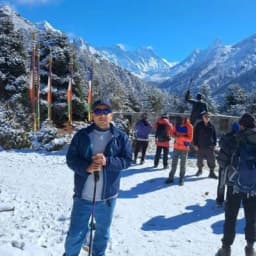
If you want to feel like a real explorer, the Everest High Passes Trek is a journey worth telling. This 19-day trek makes a full loop through the world’s highest mountains and goes far beyond a normal walk. You cross three famous high passes: Kongma La Pass, Cho La Pass, and Renjo La Pass, where the air is thin, and the views feel unreal.
The trek starts and ends in Lukla, the gateway to the Everest region. The Everest High Passes Trek map shows a trail that winds across glaciers, past clear blue lakes, and into quiet Sherpa villages.
By following the Everest High Passes Trek map, you can plan for high elevation and walk at a steady pace. At Nepal Gateway Trekking, we help turn this route into a safe and unforgettable mountain journey.
Why is the Everest High Passes Trek Map Important?
While the main Everest trail is often busy, our Everest High Passes Trek map shows has quieter and wilder paths across the high passes. Once you leave the main route, a map becomes your best friend. It helps you see where the next safe lodge is and keeps you on the right trail.
The Everest Th map also helps you prepare for the high passes trek elevation, where the air is thin and breathing feels harder. By showing steep climbs and long days, it reminds you to walk “Bistari, Bistari” (slowly, slowly) and save your energy.
Why carrying a map matters:
- Stay on track: Some sections are remote with no villages for hours. The map keeps you from taking a wrong turn.
- Handle big climbs: It shows where the steep passes begin so you can pace yourself.
- Cross ice safely: On the Cho La glacier, the map helps you follow the correct markers across ice and rocks.
- Find the Gokyo Lakes: The map guides you to all the hidden blue lakes so you don’t miss any.
- Stay safe: If altitude feels tough, the map shows the quickest way down to rest.
This is why, at Nepal Gateway Trekking, we never treat the map as optional, it’s part of your safety, comfort, and success on the trail.
Don’t rely on guesswork in the high mountains. Nepal Gateway Trekking plans your Everest High Passes Trek using detailed route maps and real trail experience, so you can focus on the journey, not the risk. Get in touch today.
Overview of the Everest High Passes Trek
The Everest High Passes Trek isn't your standard walk to Base Camp. It is a massive, 19-day high-altitude loop that circles the entire Khumbu region, connecting the four major valleys: Thame, Gokyo, Khumbu, and Chhukung.
Our Everest High Passes Trek map shows a journey that is as beautiful as it is brutal. You won’t just follow the crowds; you’ll cross three legendary passes above 5,300 metres, walk across the world’s highest glaciers, and see four of the world’s 8,000-metre peaks, i.e., Everest, Lhotse, Makalu, and Cho Oyu, from angles most trekkers never see.
Quick Fact Sheet: The Everest High Passes
|
Feature |
Details |
|
Total Duration |
19 Days (Includes Kathmandu arrival & Lukla flights) |
|
Start / End Point |
Lukla (2,840m) — Gateway to the Khumbu |
|
Difficulty Level |
Very Strenuous (Top-tier physical fitness required) |
|
Maximum Altitude |
5,550m (Kala Patthar / Chhukung Ri) |
|
Best Trekking Seasons |
Spring (March–May) & Autumn (Sept–Nov) |
When you study your Everest High Passes Trek map, look for these specific markers that define the journey:
- The Three Gates: Kongma La, Cho La, and Renjo La (marked as the highest "hurdles" on your map).
- Secondary Routes: Notice the side-trips to Everest Base Camp and the Gokyo Lakes: these are essential for the full experience.
- Flight Connections: Most flights now operate via Manthali (Ramechhap) during peak season to reach Lukla safely.
- The Blue Jewels: The sacred, turquoise lakes in the Gokyo Valley.
Timing matters in the high mountains. Read our Nepal Gateway Trekking blog to learn the best season for the Everest High Passes Trek and walk with confidence.
Route and Day-by-Day Itinerary in the Everest High Passes Trek Map
When you unfold your Everest High Passes Trek map, you will notice a massive loop that circles the heart of the Khumbu. The trek begins with a thrilling flight to Lukla and continues to the Sherpa heartland of Namche Bazaar.
From there, the Everest High Passes trekking route separates from the crowded trails. You will visit Everest Base Camp, see the turquoise Gokyo Lakes, and stand on the summit of Kala Patthar.
Short Itinerary Breakdown
This table is a great "cheat sheet" to help you visualize the Everest Base Camp and High Passes itinerary. It tracks the flow of the high altitude trek Nepal Everest from start to finish.
|
Days |
Main Route Segment |
Key Milestone |
|
1–5 |
Lukla to Namche & Dingboche |
Acclimatization & Sherpa Culture |
|
6–9 |
Chhukung to Kongma La & EBC |
The Highest Pass (5,540m) |
|
10–11 |
Lobuche to Kala Patthar & Dzongla |
Ultimate Everest Sunrise View |
|
12–14 |
Cho La Pass to Gokyo Lakes |
Glacier Crossing & Blue Lakes |
|
15–19 |
Renjo La Pass to Thame & Lukla |
Final Panorama & Return to Lukla |
Expert Tip: Look closely at the Kongma La route on your map. It is the loneliest part of the trek with no tea houses. Always carry extra water and a headlamp before you leave Chhukung that morning!
If the full Three Passes Trek feels too long, our Everest Gokyo Renjo La Pass Trek is a great and slightly shorter alternative. Contact Nepal Gateway Trekking.
Altitude Chart of the Everest High Passes Trek Map
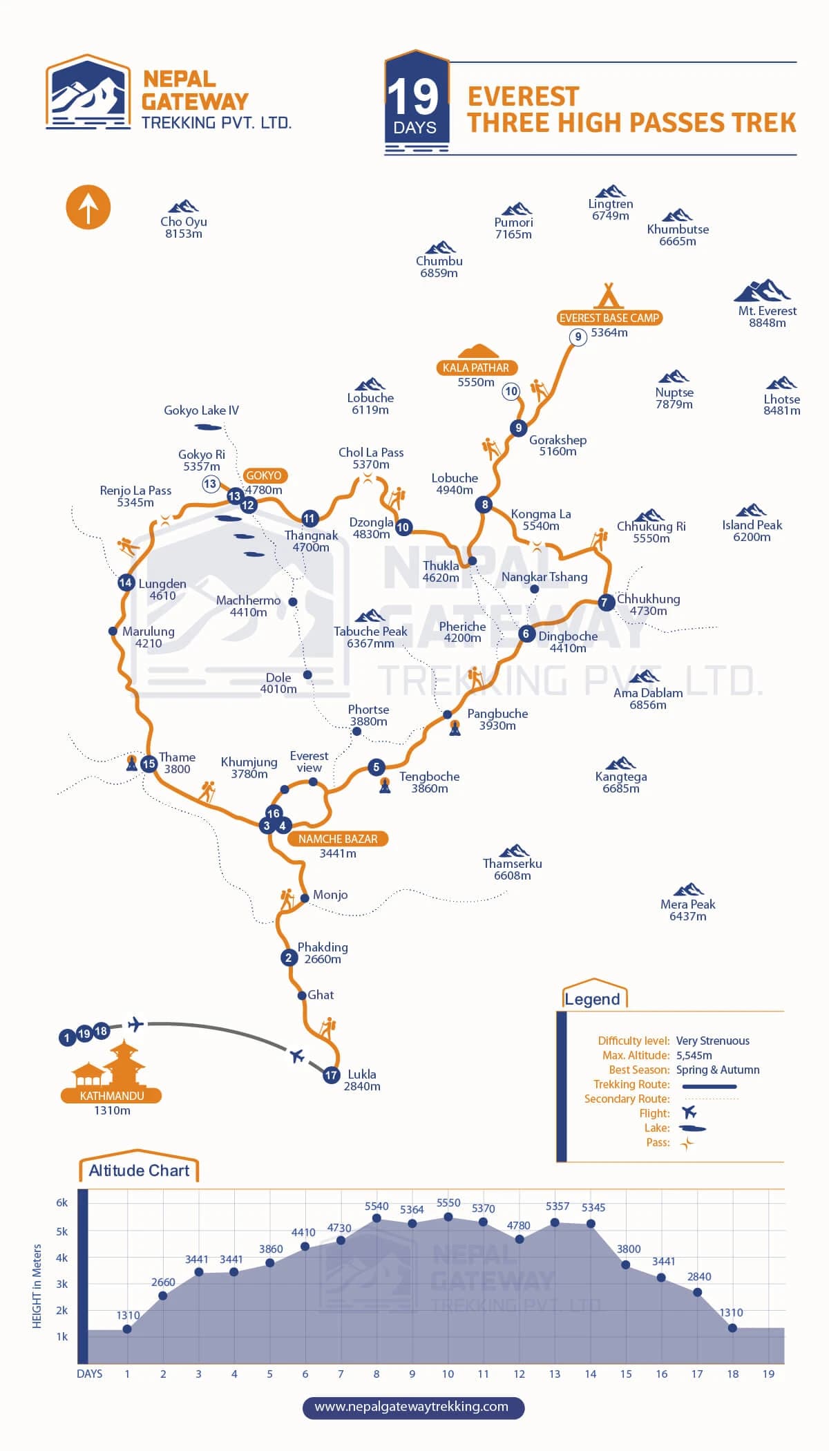
If you look at an altitude chart for the Three Passes Trek map in Nepal, it looks like the jagged teeth of a saw. You "climb high and sleep low" to help your body adapt. Managing this high-passes trek elevation is the most important part of your safety.
By following our Everest High Passes Trek map, you can see exactly where the air gets thin. We have highlighted the "Hero Days" where you hit the highest points.
|
Day |
Route Segment |
Altitude (m) |
Guide’s "Trail Note" |
|
1 |
Kathmandu → Lukla |
1,310 → 2,840 |
The mountain flight that starts it all. |
|
2 |
Phakding → Namche Bazaar |
2,660 → 3,441 |
Crossing the high Hillary Bridge. |
|
3 |
Namche Bazaar (Rest) |
3,441 |
CRITICAL: Don't skip this acclimatization day. |
|
4 |
Namche → Tengboche |
3,860 |
Sunset views at the monastery are legendary. |
|
5 |
Tengboche → Dingboche |
4,410 |
You’ll feel the temperature drop here. |
|
6 |
Dingboche → Chhukung |
4,730 |
Final prep before the first big wall. |
|
7 |
Kongma La Pass |
5,540 |
Highest pass elevation on the map. |
|
8 |
Lobuche → Everest Base Camp |
5,364 |
Standing at the foot of the world's giant. |
|
9 |
Kala Patthar |
5,550 |
The ultimate head-to-toe Everest view. |
|
10 |
Dzongla → Thangnak |
4,700 |
A shorter day to rest your legs. |
|
11 |
Cho La Pass |
5,370 |
Famous for the Cho La glacier crossing. |
|
12 |
Gokyo Ri Trek |
5,357 |
Best view of 8,000m peaks in the world. |
|
13 |
Renjo La Pass |
5,345 |
The final legendary mountain pass. |
|
14 |
Lungden → Dole |
4,010 |
Heading back into the tree line. |
|
15 |
Dole → Thame |
3,800 |
A quiet walk through ancient Sherpa culture. |
|
16 |
Thame → Namche Bazaar |
3,441 |
Back for that victory coffee and brownie! |
|
17 |
Namche Bazaar → Lukla |
2,840 |
The long walk home through the valley. |
|
18 |
Lukla → Kathmandu |
1,310 |
Flight back and a hot shower. |
|
19 |
Final Departure |
1,310 |
End of a life-changing adventure. |
Expert Tip: On the Everest Trek altitude chart, you crossed 5,000 metres four times! At Nepal Gateway Trekking, we use the phrase "Bistari, Bistari" (Slowly, Slowly). Drinking 4 litres of water per day is the best way to handle the high pass.
Want a shorter Everest experience? Join Nepal Gateway Trekking on the Gokyo Lakes Trek, a 14-day journey with stunning mountain and lake views.
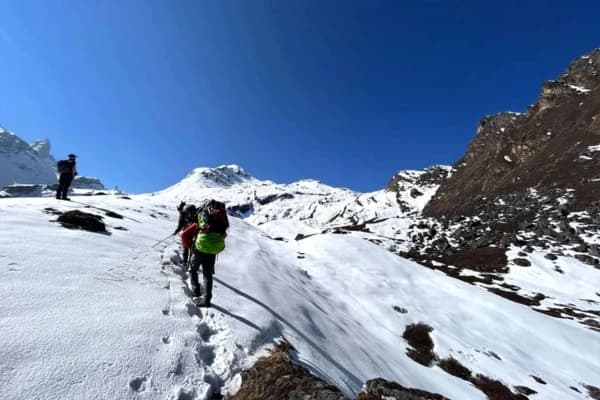
Major Passes Seen on the Trek Map
When you open your Everest High Passes Trek map, you’ll see three major passes. These are the giant gates of the Himalayas. They are high, they are snowy, and crossing them is the highlight of the whole trip.
On the Everest High Passes trekking route, you don’t just walk in a straight line. You climb over three massive ridges.
Kongma La Pass
The Kongma La elevation is 5,540 metres. On most maps, this is your first big test. The Kongma La Pass map overview shows a rocky, wild, and feels like the edge of the world.
- Connects: This path connects the quiet village of Chhukung to the rocky settlement of Lobuche.
- Highlights: The Kongma La route gives you a "front-row seat" to see Mt. Everest, the massive face of Lhotse, and the beautiful Ama Dablam.
- Guide Insight: This pass is usually very empty. You won’t see the big crowds here, which makes it feel like a true, private adventure.
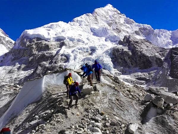
Cho La Pass
The Cho La Pass stands at 5,370 metres. If you check your Cho La Pass trekking information, you’ll notice this section looks different. That’s because it involves a real ice adventure.
- Connects: It takes you from the rocky camp at Dzongla over into the stunning Gokyo Valley.
- Features: This is the legendary Cho La glacier crossing. You will actually walk across a river of ice! You must watch out for "crevasses," which are deep, hidden cracks in the glacier.
- Guide Insight: We always tell our trekkers to carry "micro-spikes" in their packs. Even if the sun is shining, the ice on the pass is slippery and doesn't care about your fancy boots!
If you've always wanted to walk to Everest Base Camp and cross Cho La Pass, Nepal Gateway Trekking offers a longer alternative trek that combines the two experiences into one adventure: Everest Base Camp Cho La Pass Trek.
Renjo La Pass
The Renjo La Pass route details mark this final pass at 5,345 meters. Many of our team members at Nepal Gateway Trekking think this is the most beautiful spot in the entire Khumbu region.
- Connects: It links the turquoise Gokyo Lakes to the quiet, traditional valley of Lungden.
- Views: These are the real Renjo La trek highlights. When you stand at the top, you look back at the blue lakes and see a massive "wall" of mountains, including Everest and Makalu, right in front of your eyes.
- Guide Insight: The path down toward Lungden is made of neat stone stairs built by local people.
Want the ultimate Everest experience? Explore the best trekking route in the Everest Region with expert tips and insights!
Highlights Along the Route in the Map

Your Everest High Passes Trek map is more than just a set of directions. It is a treasure map for some of the most legendary spots on Three passes Trek Map Nepal.
The major highlights along the route in this map are:
Everest Base Camp (5,364m)
Everest Base Camp is considered the "heart" of the Khumbu region. When you arrive here, you will be standing in a historical site. This location is where climbers' dreams of reaching the top of the world begin.
The Experience: You’ll walk through a maze of rocks and ice, seeing the massive Khumbu Icefall towering above you.
Kala Patthar Sunrise Viewpoint (5,550m)
On your map, you’ll find a small, dark peak sitting just above Gorak Shep. This is Kala Patthar. It is the highest point most people will ever reach on foot.
- The View: This is the ultimate "camera-ready" spot. While Everest is hidden from Base Camp, it stands front and center here. Watching the sun turn the summit from white to gold is a true spiritual moment.
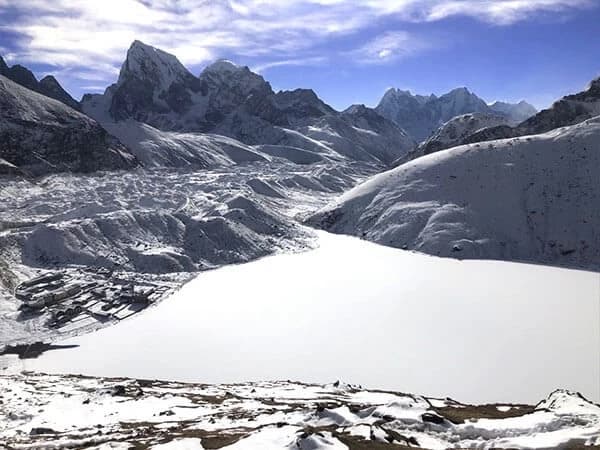
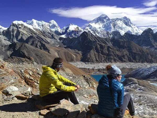
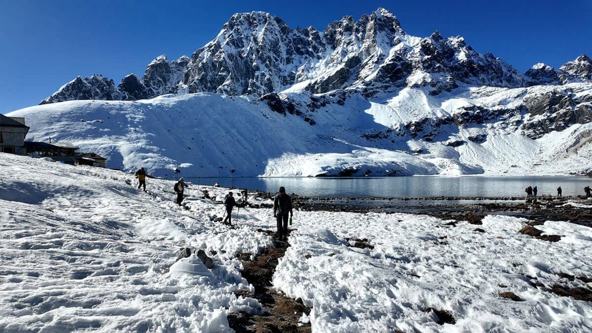
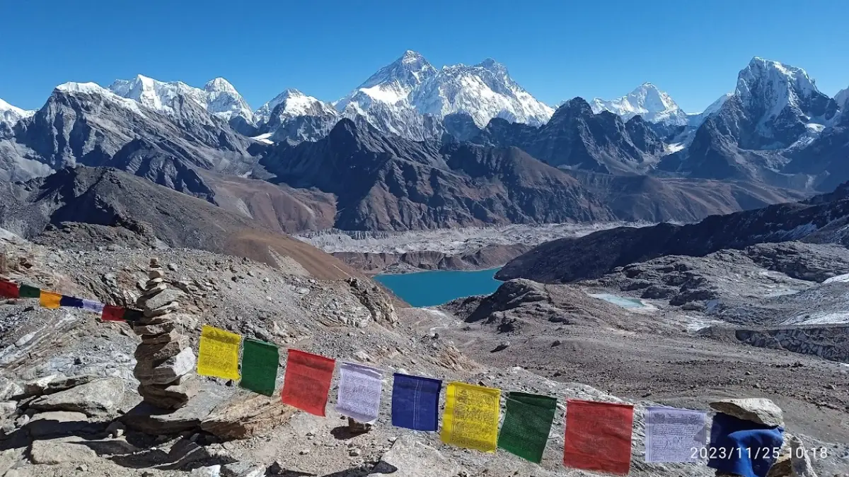
Gokyo Lakes & Gokyo Ri
The Gokyo Valley Trek feels like a hidden world. Your map shows six "Turquoise Lakes" that look like bright jewels dropped into a bowl of snow.
- Gokyo Ri View: Climbing to the top of Gokyo Ri (5,357m) gives you a panorama of four "8,000-meter" peaks at once. Many of our local guides actually think this Gokyo Ri view is even more impressive than the view from Kala Patthar.
Curious about Gokyo Lakes? Take a moment to learn how high Gokyo Lake is and why altitude matters.
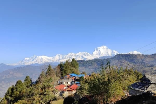
Sherpa Villages: Namche, Tengboche, and Dingboche
The Everest High Passes Trek map isn't all about ice and rock. It also shows you where the heart of the Sherpa people beats.
- Namche Bazaar: The "Sherpa Capital" is a horseshoe-shaped town built into a mountain. It’s got everything from cozy bakeries to gear shops.
- Tengboche: This is the spiritual soul of the region. You can visit the massive monastery and hear the monks' horns echoing against the mountain walls.
- Dingboche: A beautiful village surrounded by stone walls to protect crops from the high-altitude wind.
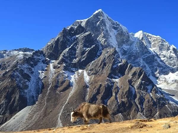
Glaciers: Khumbu and Cho La Glacier
You don’t just look at these glaciers from a distance; you actually cross them.
- Khumbu Glacier: The highest glacier in the world. It looks like a massive, frozen river made of grey rocks and white ice.
- Cho La Glacier: Crossing this is a real highlight of the high altitude trek Nepal Everest. You’ll need a steady foot and sharp eyes to navigate across the solid, blue ice. It’s a great place to take a slow walk and just soak in the sunset.
Summary: Why the Map Makes Your Trek Easy?
Think of the Everest High Passes Trek map as a quiet guide in your pocket. In the high mountains of Nepal, there are no clear signs, and weather can change fast. When clouds roll in, the map keeps you on the right trail and leads you safely to villages where you can rest and eat.
The map also helps you manage energy. The Everest High Passes Trek elevation is tough, and thin air makes walking harder. By checking the route each morning, you can spot steep climbs, walk slowly, take breaks, and save strength. At Nepal Gateway Trekking, we use the map to help you reach places like Gokyo Lakes safely, turning a hard trail into a clear, step-by-step journey. Contact Us Today to book your adventerous trek.
FAQ Section
What are the three passes of the Everest High Passes Trek?
The three legendary passes are Kongma La (5,535m), Cho La (5,420m), and Renjo La (5,360m). You can find all three marked clearly on your Everest High Passes Trek map as the highest hurdles of the trip.
How long is the trek and highest altitude?
This epic journey usually takes 19 days to complete the full loop. The highest points on the high passes trek elevation chart are Kala Patthar and Chhukung Ri, both reaching about 5,550m.
Which villages are on the map route?
Your map will show key stops like Namche Bazaar, Tengboche, Dingboche, and the high-altitude huts at Gokyo and Lungden. These villages are the best places to rest and eat during your long walk.
Does it include Everest Base Camp?
Yes! Most people use their Everest High Passes Trek map to add a side trip to Everest Base Camp (5,364m) after crossing the first pass. It is a highlight of the 19-day journey.
What is the best season for the trek?
The best times to go are Spring (March to May) and Autumn (September to November). These months have the clearest skies so you can see the big mountains without too many clouds.
Is a guide required?
While you are allowed to walk some trails alone, having a guide from Nepal Gateway Trekking is much safer for the high passes. We help you find the way if the trail gets covered in snow or fog.
How difficult is Everest High Passes trek?
This trek is difficult because you spend many days walking very high up where the air is thin. You need to be fit and healthy to handle the steep climbs shown on the map route summary.
What gear is essential for the trek?
You must have warm layers, a good sleeping bag, and sturdy trekking boots. Please keep in mind your Everest High Passes Trek map and a pair of crampons for the slippery ice on the passes.
How much does Everest High Passes Trek cost on average?
On average, the trip costs between $1,560 and $1,710, depending on your group size and services. This usually includes your flights to Lukla, food, a guide, and all your mountain permits.
Which glaciers will I cross?
You will walk across the massive Khumbu Glacier and the Ngozumpa Glacier, which is the longest in Nepal. These are the bumpy, rocky areas on your map that look like frozen rivers.