The Mera Peak Climbing Map is really important for anyone getting ready to climb Mera Peak. At 6,476 meters, Mera Peak is Nepal’s highest trekking peak and attracts both beginners and experienced climbers from all over the world.
The map shows the whole journey clearly. It points out the main and side trails, campsites, spots to get used to the altitude, high passes, check posts, and viewpoints. Looking at the map early helps you plan your climb safely, handle the altitude, and see how the land changes from Lukla to the top.
The Mera Peak climbing map also shows how the trail goes through quiet valleys, glacier areas, and traditional Sherpa villages. For trekkers and climbers, it’s a reliable guide before and during the climb.
Mera Peak Location and Region Map
Mera Peak lies in the Solukhumbu region of Nepal. It sits to the southeast of Mount Everest inside the rugged Makalu Barun National Park. On the map, you will see how the peak is positioned away from the busy Everest Base Camp route, which makes it far quieter and less commercial.
To reach the region, climbers fly to Lukla from Kathmandu. Lukla marks the entrance to both the Khumbu and Hinku Valleys, which you can clearly see on the map. The villages, green forest lines, river valleys, and glacier zones are marked along the route toward Mera Peak.
Nearby landmarks you will recognize on the map include Chhatra Khola, Panggom, Kothe, Thaknak, and Khare. These settlements follow the Hinku Valley and offer a natural growth in elevation. This geographic layout explains how trekkers adapt slowly as they move north toward the alpine zone.
Mera Peak Climbing Itinerary (18 Days)
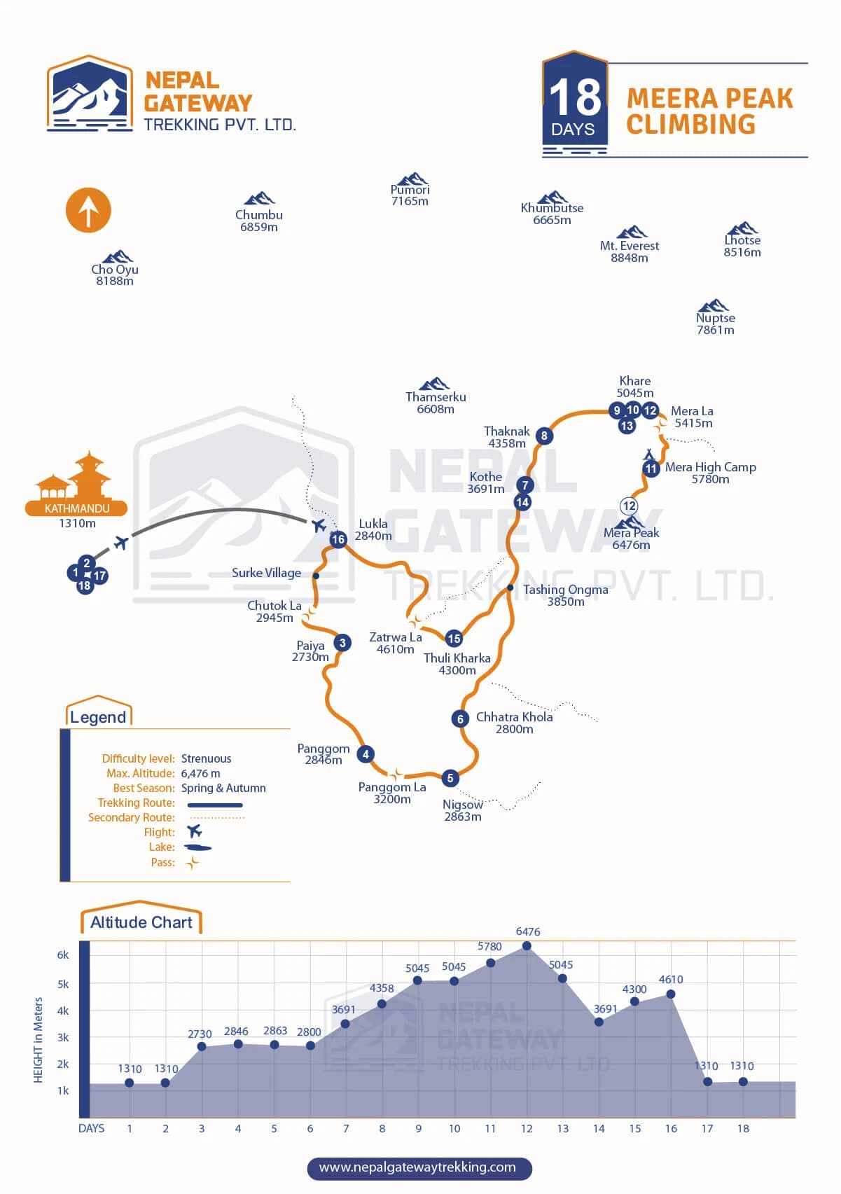
The itinerary on the map usually takes 18 days, according to Nepal Gateway Trekking, your trusted trekking agency. This gives enough time to slowly get used to the height, adjust to the altitude, and safely reach the summit. The map visually lays out where you trek, sleep, and rest each night.
Below is the simplified day-to-day outline represented on the map.
- Days 1–3: Kathmandu arrival, fly to Lukla, trek to Paiya. Easy start to adjust to the altitude.
- Days 4–6: Trek through Panggom, Ningsow, and Chhatra Khola. Gentle terrain for acclimatization.
- Days 7–9: Kothe, Thaknak, and Khare. Trail climbs into alpine zones with open mountain views.
- Days 10–12: Rest and acclimatize at Khare. Move toward Mera La while preparing for the summit.
- Days 13–15: Mera High Camp and summit push. Reach Mera Peak (6,476 m) and descend to Khare.
- Days 16–18: Return via Kothe and Zatrwa La to Lukla, then fly back to Kathmandu.
The map shows altitude gain gradually. Higher camps are spaced well apart, which is important for preventing altitude sickness. For more detailed itinerary, explore our Mera Peak Climbing Package designed for you.
Major Landmarks on the Mera Peak Climbing Map
The Mera Peak climbing map shows all the key spots from the valley up to the summit. These landmarks help trekkers find their way through forest paths, river crossings, snowfields, and glacier areas.
Every place on the map has a reason. Villages provide food and a spot to rest. Passes let you move between valleys. Check posts make sure your permits are okay and that it’s safe. Base camps help climbers get used to the thin air.
Below is a short introduction to each type of place shown on the map.
Villages and Trail Start Points on the Mera Peak Climbing Map
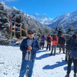
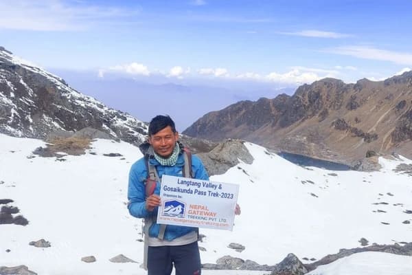
- Kathmandu (1,310 m): Your adventure starts in Nepal’s busy capital. Here, you will get your permits, meet your Sherpa guides, and get your gear ready for the trek. Kathmandu is also a good place to see local culture, buy trekking stuff, and rest before flying to Lukla.
- Surke Village: The first village on the trail after Lukla. Surke is quiet and has a traditional Sherpa feel. Trekkers can enjoy local hospitality and the valley views. It is an easy first stop to start getting used to the Himalayan environment.
- Lukla (2,840 m): Known as the gateway to the Everest region, Lukla has the Tenzing Hillary Airport. The high-altitude trek starts here. The village is small but lively, with tea houses, local markets, and great views of the hills. Trekkers also meet their teams and check the route here.
- Paiya (2,730 m): A small village along the trail with valley views. Paiya is a common stop to rest, get used to the height, and enjoy the Hinku Valley. You will also start seeing the higher Himalayan peaks.
- Panggom (2,846 m): A Sherpa village at the base of the trail to Panggom La Pass. Trekkers can see traditional farming and experience Sherpa culture while slowly gaining height.
- Ningsow (2,863 m) & Chhatra Khola (2,800 m): Small, remote villages on the trail. These stops are good for resting and getting used to the height as the trail gets harder. You will cross rivers, walk through forests, and enjoy peaceful surroundings.
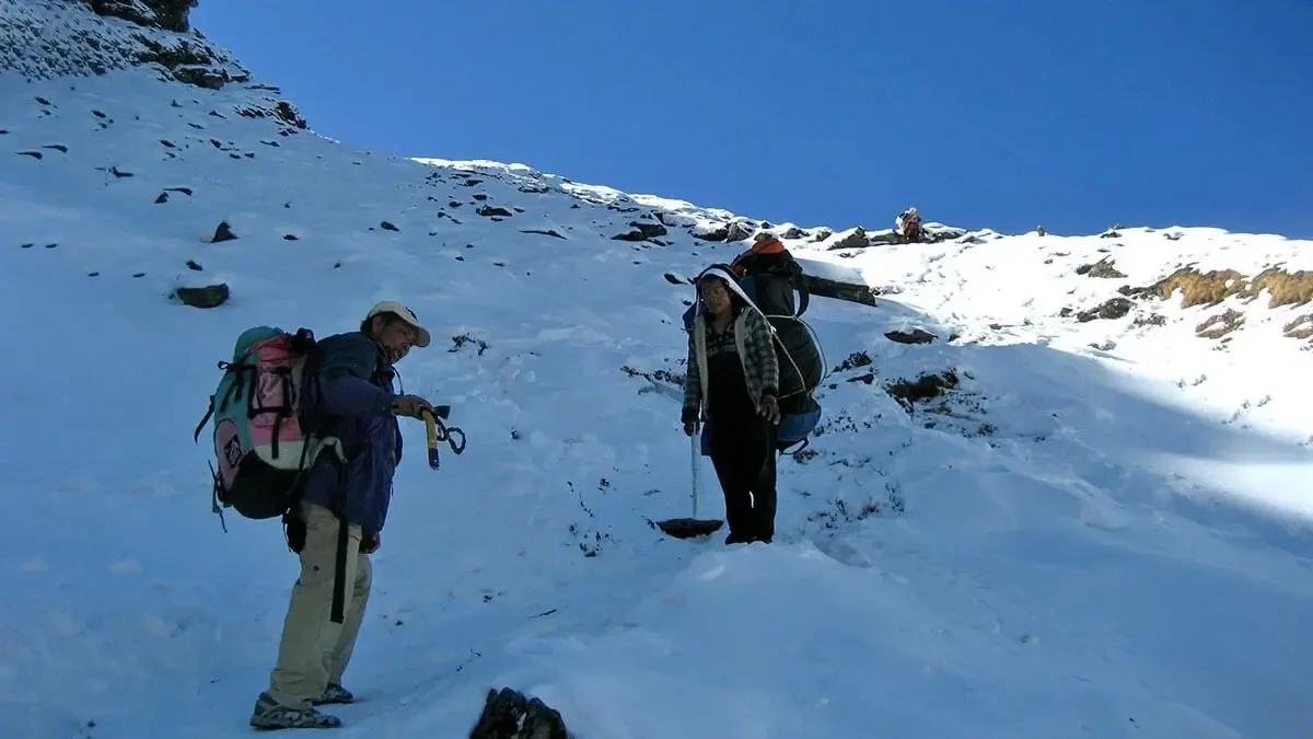
- Kothe (3,691 m) & Thaknak (4,358 m): High villages where the alpine area begins. There are fewer plants, and snow-covered peaks appear. These stops are important for resting and adjusting to the height before heading to Khare and the high camps.
Mera Peak Climb Passes on the Map
- Chutok La (2,945 m): An easy pass early on the trek. It helps trekkers warm up and get used to the height. The trail has nice views and is a good start to the Himalayan trek.
- Panggom La (3,200 m): A main pass connecting Panggom to Ningsow. The path goes up slowly and has beautiful valley views. It shows the change from forests to open alpine areas.
- Zatrwa La (4,610 m): A high pass used mostly on the way back to Lukla. From here, trekkers can see wide views of mountains and glaciers. It is one of the most scenic spots on the trail.
Major Check posts on the Mera Peak Climbing Route
The Mera Peak route has three main checkposts that are important for safety, permits, and getting used to the height:
- Khare (5,045 m): The last village before the high camps. This is the main checkpost where trekkers take care of permits, meet their guides, and get used to the height. Staying here helps you get used to the height before going to the summit.
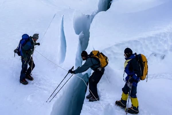
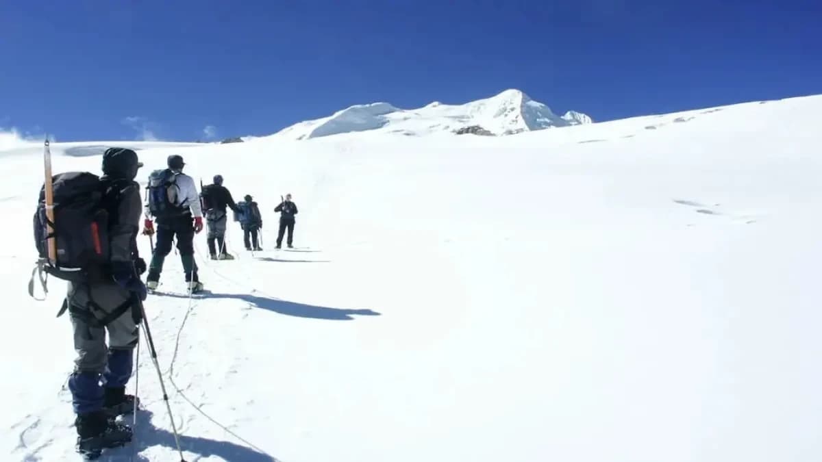
- Mera La (5,415 m): A glacier pass where the trail changes from walking to climbing. Climbers get their gear ready, check the snow and ice, and make sure they are ready for the high camp and the climb to the summit.
- Mera High Camp (5,780 m): The last stop before the summit. Climbers rest, adjust to the height, and get their gear ready for a climb to the top of Mera Peak, usually at midnight or early morning.
Base and High Camps in the Mera Peak Climb
The Mera Peak climbing map shows the main camps where trekkers rest, get used to the height, and get ready for the summit.
- Khare Camp (5,045 m): The main camp to adjust to the height. Lodges are here for trekkers to rest. Staying at Khare helps climbers get used to the height and prepare for the climb ahead.
- Mera High Camp (5,780 m): The last high camp. Climbers rest in tents and get their gear ready before trying to reach the summit.
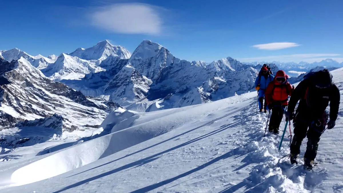
Summit Seen on the Mera Peak Climbing Map
The map shows Nepal’s highest trekking peak and the amazing views climbers can see.
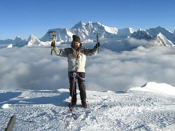
- Mera Peak (6,476 m): From the top, trekkers can see wide views of Everest, Lhotse, Nuptse, Makalu, Thamserku, and Chumbu.
Surrounding Himalayan Peaks Visible from Mera Peak
From the top of Mera Peak, the views are stunning. You can see many famous mountains in the Himalayas:
- Everest (8,848 m): The tallest mountain in the world, towering above everything.
- Lhotse (8,516 m): Right next to Everest, part of the same mountain group.
- Nuptse (7,861 m): Close to Everest and easy to spot from the summit.
- Cho Oyu (8,188 m): A large mountain far away that looks amazing from here.
- Pumori (7,165 m): Along the Hinku Valley, a favorite for trekkers to admire.
- Chumbu (6,859 m): Near Khare, adding more charm to the alpine scenery.
- Khumbutse (6,665 m): Part of the Khumbu skyline, clear on sunny days.
- Thamserku (6,608 m): A tall peak visible while trekking toward Khare.
Seeing all these peaks together is unforgettable. The view goes in every direction and makes the climb completely worth it. Explore the mountains in the South Asia to see how these white beauty catches your heart.
Altitude Chart & Trekking Profile of Mera Peak Climbing Map
The Mera Peak map shows the height from Kathmandu (1,310 m) up to the summit (6,476 m). It helps trekkers plan rest days, know where to get used to the height, and prepare for the passes and camps.
The trek starts in Kathmandu, goes through villages and valleys, crosses moderate and high passes, and reaches the base and high camps before the summit. Key places to adjust to the height are Khare Camp and Mera High Camp.
Check posts are for permits, and high passes like Zatrwa La give amazing views. With its villages, passes, camps, and the summit, Mera Peak is one of the best trekking peaks in Nepal.
Quick Reference of Major Landmarks on the Mera Peak Route
|
Type |
Landmark |
Elevation |
Notes |
|
Village |
Kathmandu |
1,310 m |
Starting point: arrange permits and meet guides |
|
Village |
Surke |
2,290 m |
Early trekking stop; traditional village |
|
Village |
Lukla |
2,840 m |
Gateway to the trek: Tenzing–Hillary Airport |
|
Village |
Paiya |
2,730 m |
Scenic valley stop |
|
Village |
Panggom |
2,846 m |
Base for Panggom La pass |
|
Pass |
Chutok La |
2,945 m |
Early trekking pass; gentle climb |
|
Pass |
Panggom La |
3,200 m |
Mid-level pass connecting valleys |
|
Pass |
Zatrwa La |
4,610 m |
High alpine pass; panoramic mountain views |
|
Check Post |
Khare |
5,045 m |
Main check post; acclimatization stop |
|
Check Post |
Mera La |
5,415 m |
Glacier Pass; start of climbing terrain |
|
Camp |
Mera High Camp |
5,780 m |
Final high camp; rest before summit |
|
Summit |
Mera Peak |
6,476 m |
Nepal’s highest trekking peak; 360° Himalayan views |
|
Surrounding Peaks |
Everest, Lhotse, Nuptse, Makalu, Cho Oyu, Pumori, Chumbu, Khumbutse, Thamserku |
6,600–8,848 m |
Visible from the summit; panoramic Himalayan scenery |
This altitude chart and trekking profile are helpful guides for climbers and trekkers. It makes planning the route, adjusting to the height, and tracking progress easier, helping you have a safe and enjoyable journey to the summit of Mera Peak.
Tips for Using the Mera Peak Climbing Map
- Look at the map before leaving Kathmandu to get familiar with the villages and camps.
- Keep an eye on passes and altitude markers to see where the trail is steep.
- Use check posts to track your progress and make sure your permits are ready.
- Bring both a printed map and a GPS file on your device.
- Take breaks to adjust to the altitude.
- Every evening, go over the next day’s route with your guide.
Final Thoughts
Mera Peak is an exciting trek and climb in the Himalayas. The Mera Peak Climbing Map helps you plan your route, follow your progress, and stay safe. It shows the heights, camps, passes, and key landmarks on the trail.
For the best experience, climb with an expert team. Nepal Gateway Trekking offers experienced Sherpa guides, help with permits, and local knowledge to take you safely from Kathmandu to the summit of Mera Peak. Contact us today to get ready for your Mera Peak Climb.
Frequently Asked Questions
Do I need a guide to climb Mera Peak?
Yes. A licensed guide is highly recommended. They keep you safe, help you cross glaciers, and guide you through crevasses and high-altitude challenges.
How long does the climb take?
Most climbs take about 18 days from Kathmandu to Kathmandu, including rest days to adjust to the height and prepare for the summit.
What is the difficulty level of Mera Peak?
Mera Peak is a trekking peak with some basic climbing. Near the summit, climbers use crampons and ropes, so it’s best for those with some training.
Can beginners attempt Mera Peak?
Yes. Beginners can climb with a guide, proper rest to adjust to the height, and basic climbing training.
When is the best time to climb Mera Peak?
Spring (March–May) and autumn (September–November) have the best weather, clear skies, and safe snow conditions to climb Mera Peak.
How do I get permits for Mera Peak?
You need a Mera Peak climbing permit and entry to Makalu Barun National Park. Trekking agencies like Nepal Gateway Trekking handle all the permits and paperwork.
Are there alternate routes to Mera Peak?
Yes. The main route through the Hinku Valley is the safest. Other routes, like via Zatrwa La, are harder and best for experienced climbers only.
Which viewpoints should I not miss on Mera Peak?
Don’t miss Khare Camp, Mera High Camp, and the summit ridge. They give amazing views of Everest, Lhotse, Makalu, Cho Oyu, Nuptse, and other Himalayan peaks.