Standing at 7,219 meters (23,684 ft), Annapurna South is the 100th highest mountain in the world and the 5th highest peak in the Annapurna range. It goes by two name's Annapurna South (अन्नपूर्ण दक्षिण in Nepali) and Modi Peak or Moditse, named after the Modi Khola river valley below it.
Here's the thing most people don't know: millions of trekkers and tourists see this mountain every year from Pokhara, from Poon Hill, and from the trail to Annapurna Base Camp, and most of them have no idea what it's called.
They're looking at one of the hundred highest mountains on Earth and calling it by the wrong name.
Three things make Annapurna South genuinely worth knowing about. The 1964 first ascent by a Japanese university climbing team is a seriously underappreciated story. Secondly, Ueli Steck's 2013 solo on the south face, which is a different level of boldness.
Third, it dominates the skyline of some of Nepal's most beloved trek viewpoints, yet it never receives the credit it deserves.
Annapurna South: Quick Facts
|
Fact |
Detail |
|
Other names |
Modi Peak, Moditse |
|
Elevation |
7,219 m / 23,684 ft |
|
World ranking |
100th highest mountain |
|
Range ranking |
5th highest in Annapurna range |
|
Province / Districts |
Gandaki / Myagdi & Kaski |
|
Coordinates |
28° 31' 06" N, 83° 48' 29" E |
|
First ascent |
October 15, 1964 |
|
Status |
Open for climbing |
|
Related peak |
Hiunchuli (6,441 m) |
Where is Annapurna South located?
Annapurna South sits in the Annapurna Himal, Gandaki Province, right on the border of Myagdi and Kaski districts. It's positioned directly south of Annapurna I (8,091 m), separated by the upper Modi Khola valley.
One thing that constantly confuses first-time visitors: Annapurna South is not the same as Machhapuchhre (Fishtail). Machhapuchhre (6,993 m) sits closer to Pokhara and has that sharp, dramatic twin-peak silhouette.
Annapurna South is actually taller, but it sits further back behind Machhapuchhre from the city's perspective. Two entirely different mountains. Although they are easily confused, it is important to understand their differences.
Its geographical extension, Hiunchuli (6,441 m), shares the same massif and connects with the southeastern ridge. If you've been to Annapurna Base Camp, you've seen both of them towering above the camp.
What Does the Mountain Actually Look Like?
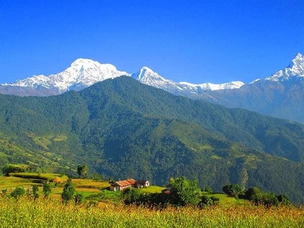
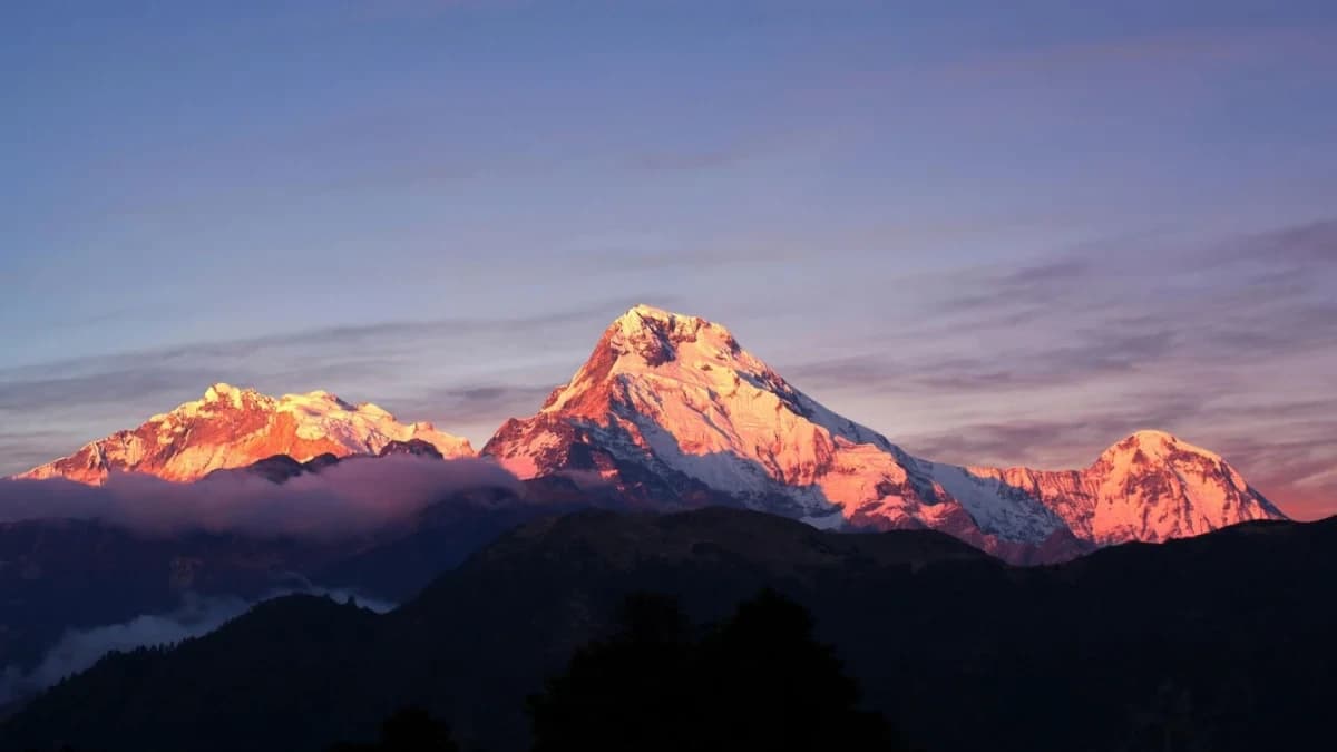
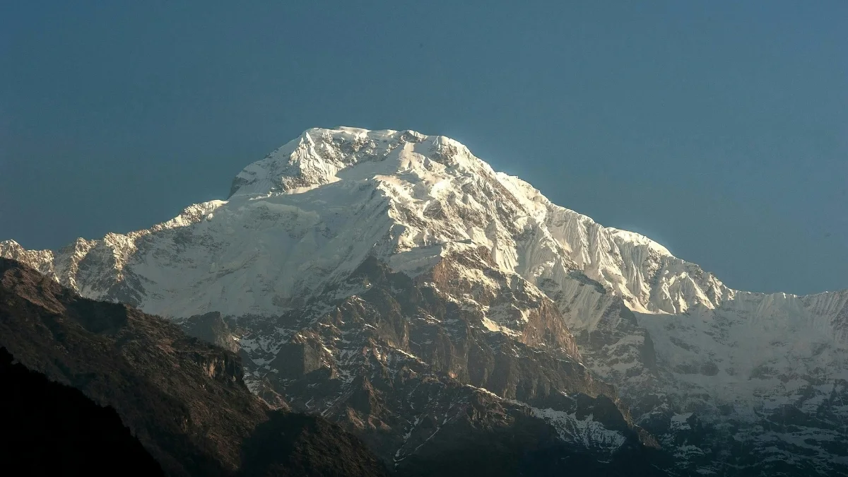
The south face is the defining feature. It's a massive wall of ice, snow, and mixed terrain, roughly 3,200 m from the valley floor to the summit. When you are standing at Poon Hill or gazing from Pokhara's lakeside, that is the view you are observing.
The summit structure is actually three distinct peaks central, north, and south. The south peak is the true highest point.
This fact wasn't confirmed until the 1964 first ascent team stood on the central peak and realized they still had higher ground ahead of them. The South Annapurna Glacier sits at the base camp level.
The Ganesh Glacier, located along the northern approach, is where the original expedition established Camp I. At approximately 6,200 m, there is a notorious overhanging ice wall, the technical crux that halted several teams before they could continue their ascent.
Ghorepani poon hill trek is one of the most beautiful and family trek in Nepal.
The First Ascent - “1964”
This section is the part of Annapurna South's story that deserves way more attention.
Team: A six-person expedition from the Kyoto University Alpine Club, Japan
What makes their story intriguing is how they ended up on Annapurna South in the first place. They originally had a permit for Dhaulagiri IV. A British team held that permit, and it fell through, so they pivoted entirely, regrouped, and aimed for Annapurna South instead.
That kind of adaptability, redirecting a full Himalayan expedition to an entirely different mountain mid-plan, is remarkable. They left Pokhara airfield on September 9, 1964, with 4 Sherpas, 54 porters, and a liaison officer.
Camp-by-Camp Ascent
|
Date |
Camp |
Altitude |
Notes |
|
Sep 15 |
Base Camp |
~4,000 m |
South Annapurna Glacier ablation zone |
|
Sep 21 |
Camp I |
4,100 m |
Moraine of Ganesh Glacier — after 4-day recon |
|
Sep 27 |
Camp II |
5,200 m |
— |
|
~Oct 4 |
Camp III |
5,600 m |
Several days were spent finding safe route through avalanche terrain |
|
Oct 6 |
Camp IV |
6,200 m |
Under overhanging ice-wall |
|
Oct 12 |
Camp V |
6,600 m |
Snow terrace just below main summit ridge |
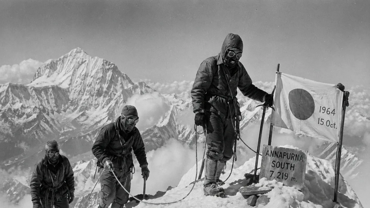
Summit Day — October 15, 1964
- On October 13, the first assault team reached the central peak and only then discovered the north and south peaks were higher. They were unable to continue due to the late hour. So they came back.
- On October 15, two separate two-person teams made simultaneous bids for the north and south summits. The south summit team crossed the central peak and reached the true highest point at noon.
First summiters: Shiochiro Uyeo (Japan) and Mingma Tsering Sherpa (Nepal).
Poor conditions prevented the North Summit team from reaching their destination. Uyeo and Mingma Tsering reached the true summit of Annapurna South, a feat confirmed only on the day of their first ascent.
Notable Climbs After 1964
Annapurna South has a short but serious climbing history. The south face has been the site of nearly every major climb since the first ascent, making it one of the most difficult walls in the Annapurna range.
|
Year |
Expedition |
Achievement |
|
1964 |
Kyoto University Alpine Club (Japan) |
First ascent — Shiochiro Uyeo & Mingma Tsering Sherpa |
|
1970 |
British expedition |
First major route variation — south pillar |
|
1981 |
Japanese expedition |
Second distinct pillar route on the south face |
|
2013 |
Ueli Steck (Switzerland) — solo |
A new ~2,500 m route through the gully between the 1970 and 1981 pillar lines was completed in a single push |
Steck's 2013 solo is worth pausing on. A new 2,500-meter line on the south face was climbed alone in one push. It sits between the British pillar from 1970 and the Japanese pillar from 1981, cutting its path through terrain nobody had taken before.
It's widely considered one of the most audacious solo ascents in Himalayan climbing history.
Annapurna South in the Annapurna Range
Annapurna South is not a sub-peak of Annapurna I. It's a fully independent summit with its own distinct climbing history, routes, and first ascent. The name implies a southern position in the range, which is accurate, but that doesn't mean it's a lesser or dependent peak.
|
Peak |
Height |
World Rank |
First Ascent |
|
Annapurna I Main |
8,091 m |
10th |
1950 |
|
Annapurna II |
7,937 m |
29th |
1960 |
|
Annapurna III |
7,555 m |
42nd |
1961 |
|
Annapurna IV |
7,525 m |
44th |
1955 |
|
Annapurna South |
7,219 m |
100th |
1964 ← this peak |
|
Hiunchuli (extension) |
6,441 m |
— |
1971 |
Where Can You See Annapurna South From?
This mountain is visible from many places in the Annapurna region, so you might be surprised how often you have already seen it without realizing it.
On the ABC & Annapurna Circuit Trek
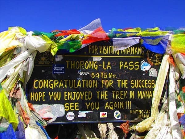
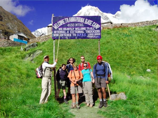
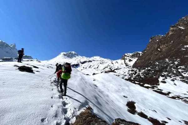
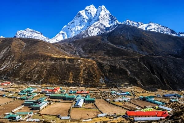
- Annapurna Base Camp (4,130 m): The closest and most dramatic view. Annapurna South forms the entire southern wall of the ABC amphitheater. It's right above you.
- Machapuchare Base Camp (3,700 m): With a clear direct sightline, the peak fills the southern skyline.
- Deurali (3,230 m): Annapurna South becomes prominent as the valley opens up above here.
- Chhomrong (2,170 m): One of the earliest points where it comes clearly into view above the Modi Khola valley.
- Jhinu Danda (1,760 m): Lower elevation but visible on clear mornings.
From Surrounding Ridges & Peaks
- Mardi Himal (5,587 m): The summit and high camp offer a face-on view across the Modi Khola. One of the best elevated viewpoints outside the ABC route. Check out the Mardi Himal Trek if you want a quieter alternative.
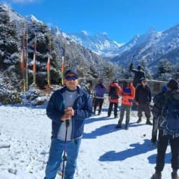
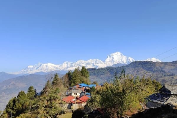
- Poon Hill (3,210 m): The most popular sunrise viewpoint in the whole Annapurna region. Annapurna South is clearly part of that panorama alongside Dhaulagiri and Machhapuchhre.
- Ghorepani (2,860 m): Wide Himalayan panorama from the ridge above the village.
- Khopra Ridge / Khopra Danda (3,660 m): Less-traveled but unobstructed views of Annapurna South and Hiunchuli. Worth it if you want to avoid the crowds.
- Australian Camp (2,060 m): A short hike from Pokhara, Annapurna South is identifiable on clear days.
From Pokhara
- Sarangkot (1,592 m), a classic sunrise spot near Pokhara. Annapurna South is part of the full-range panorama.
- Pokhara Lakeside On clear autumn and winter mornings, Annapurna South is visible rising behind Machhapuchhre from the lakeside.
- Phewa Lake reflects the Annapurna range in still mornings. Honestly one of the most beautiful views in Nepal, and Annapurna South is part of it.
Just remember: from Pokhara, Machhapuchhre (Fishtail) appears sharp and close. Annapurna South is the taller one sitting behind it. Different mountain, different story.
When is the Best Time to See Annapurna South?
Autumn and Spring are the best time to see Annapurna South clearly.
-
Autumn (Sep–Nov): Clear blue skies after rain make this season the best time to see the mountain from Poon Hill, Sarangkot, and Annapurna Base Camp.
-
Spring (Mar–May): Bright mornings and blooming rhododendrons make views beautiful, though light haze can show up later in the day.
-
Winter (Dec–Feb): Cold but very sharp views on clear days, with easy access still possible at lower viewpoints.
-
Monsoon (Jun–Aug): Thick clouds cover the mountains most of the time, so clear views are rare.
Visiting the Annapurna South Region
This section gives a brief look at the practical side of the trek's difficulty, cost, and route. It helps you understand what to expect before visiting places like Annapurna Base Camp.
How Difficult is the Trek?
The Annapurna Base Camp trek, the closest viewpoint, is graded moderate. We're talking 7 to 12 days on well-maintained trails through Gurung villages, rhododendron forests, and river valleys. No technical climbing.
The challenge is altitude gain and daily walking hours, not difficult terrain. Poon Hill is easier, 4 to 5 days, and suitable for most fitness levels. Beginners can do either route with decent preparation and a qualified guide.
You can also explore Gurung people and culture in Nepal on the trial.
How Much Does it Cost?
Budget trekkers can complete the ABC route for roughly $500–$700, including permits, a guide, food, and accommodation. Mid-range guided packages typically run $900–$1,200. Permit costs for foreigners: ACAP $30 + TIMS $20.
Full details on the Annapurna Base Camp Trek permit page. These costs are for trekking to see the mountain. Climbing permits are separate $500 in spring and $250 in autumn for foreigners.
Final Thoughts
Annapurna South doesn't get the fame of Annapurna I, Everest, or even Machhapuchhre. But at 7,219 meters, it's one of the hundred highest mountains on Earth, which is extraordinary company. The 1964 first ascent alone deserves more attention.
A team that pivoted from a different mountain entirely, worked methodically through avalanche terrain and overhanging ice, and discovered on summit day that the true top was further than they thought that's real mountaineering.
Then there's Ueli Steck in 2013. A new 2,500-meter route on the south face was soloed in a single push. This was one of the most daring ascents in the history of the Himalayas.
For most people, Annapurna South will be the mountain that fills the southern wall at ABC, the peak at sunrise from Poon Hill, and the giant reflected in Phewa Lake. That's more than enough.
Few mountains in Nepal are so visually present across so many stunning viewpoints and yet so rarely the subject of the conversation. Now you know its name. And its story.
Are you prepared to witness Annapurna South in person? Nepal Gateway Trekking runs expert-guided treks through the Annapurna region, ABC, Poon Hill, Mardi Himal, and more. Contact us today.
FAQs - Annapurna South
What makes Annapurna South different from Annapurna I?
They're two completely separate mountains. Annapurna I (8,091 m) is the 10th highest mountain in the world and one of the most dangerous 8,000 m peaks. Annapurna South (7,219 m) is an independent summit about 7 km to the south, with its own first ascent, routes, and climbing history.
Who first climbed Annapurna South?
Shiochiro Uyeo (Japan) and Mingma Tsering Sherpa (Nepal) on October 15, 1964, as part of the Kyoto University Alpine Club expedition.
What is Modi Peak?
Modi Peak, also called Moditse, is the alternative name for Annapurna South. It's named after the Modi Khola river valley directly below the mountain.
Is Hiunchuli part of Annapurna South?
Yes. Hiunchuli (6,441 m) is geographically an extension of Annapurna South, sharing the same massif on its southeastern ridge.
What is Ueli Steck's connection to Annapurna South?
In 2013, Swiss alpinist Ueli Steck soloed a new ~2,500 m route on the south face threading between the 1970 British and 1981 Japanese pillar lines considered one of the boldest solo ascents in Himalayan climbing history.
From where can you best see Annapurna South?
The best views are from Annapurna Base Camp (4,130 m), where it dominates the southern amphitheater wall, and from Poon Hill (3,210 m) for the classic panoramic sunrise view. Also clearly visible from Mardi Himal High Camp, Khopra Ridge, and Sarangkot near Pokhara.
Is Annapurna South the same as Machhapuchhre?
No. They're two separate peaks. Machhapuchhre (Fishtail, 6,993 m) is closer to Pokhara and appears sharper from the city. Annapurna South (7,219 m) is actually taller and sits behind it. First-time visitors to Pokhara and Sarangkot often confuse the two.
How difficult is the trek to see Annapurna South?
The ABC trek is graded moderate, 7 to 12 days, with no technical climbing needed. Beginners can complete it with adequate fitness and a guide. Poon Hill is easier at 4 to 5 days and suits most fitness levels.
How much does it cost to visit the Annapurna South region?
Budget: $500–$700 for the ABC route. Mid-range guided packages: $900–$1,200. Permits: ACAP $30 + TIMS $20 for foreigners. These figures are for trekking only, not climbing.