If you've been keeping an eye on Nepal's trekking scene lately, you've probably heard whispers about a brand-new corridor taking shape in the west, some call it the Danphe Route Nepal, and others know it as the Danphe Trail Nepal.
Either way, people are talking about it as one of the country's most ambitious eco-tourism projects, and frankly, the far-western regions deserve this kind of attention.
This isn't just another trekking trail. It got a real boost when it was officially included in the national development budget, which basically signals that the government is serious about turning this corridor into something lasting.
What makes it special is the direction it takes. Instead of looping around one valley like most popular treks, this one stretches across the country from west to east.
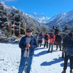
It starts in the open plateaus of Khaptad National Park and finishes at the sacred heights of Muktinath Temple. So who is this trek for? Pretty much anyone who loves the idea of getting somewhere before the crowds arrive.
Pioneering trekkers, people who care about wildlife conservation, and travelers searching for a fresh Western Nepal trekking route will all find something here.
Quick Review
- A government-backed eco-tourism trekking corridor in Western Nepal called "Danphe Trekking Route" or "Danphe Route".
- Connects Khaptad National Park to Muktinath Temple.
- Expected to be more than 35 days trekking.
- Named after Nepal's national bird, the Danphe (Himalayan Monal).
- Promotes sustainable tourism and wildlife conservation.
- Helps reduce overcrowding in Everest and Annapurna regions.
- Supports local jobs through homestays, guides, and tourism businesses.
- Major destinations include Khaptad, Ramaroshan, Badimalika, Budhinanda Lake, Rara Lake, Swargadwari, and Muktinath.
- Full Danphe Trekking route is still under development.
- Key sections like Khaptad, Rara, and Muktinath already welcome visitors.
- Difficulty ranges from easy to challenging depending on the section.
- Best trekking seasons are spring (March–May) and autumn (September–November).
- Aims to become a flagship sustainable trekking route in Nepal.
What Is the Danphe Route in Nepal?
At its core, the Danphe Route Nepal is a high-altitude strategic trekking belt that runs across four provinces: Sudurpaschim, Karnali, Lumbini, and Gandaki. The bigger picture here is pretty simple.
Nepal's most famous trails view, think Everest and Annapurna Himalaya, are seeing far too much foot traffic, and the infrastructure in those areas is under severe strain during peak seasons.
The Danphe Trekking Route was officially announced in the federal budget for the fiscal year 2083/84 B.S by Finance Minister Dr. Swarnim Wagle, in order to develop a sustainable high-hill eco-tourism trail across Nepal’s less-explored far-western and mid-western highlands.
The government's vision with this corridor is to ease that pressure by building up sustainable infrastructure in the remote western regions instead.
Sections of the Khaptad to Muktinath Route are already drawing attention from trekkers who want something different from the usual circuits, and that interest is part of what's pushing this project forward.
Interested in exploring Nepal beyond the Everest and Annapurna regions? Nepal Gateway Trekking can help you plan customized adventures to some of the country's most remote and rewarding destinations.
Why Is It Called the Danphe Route?
The name comes straight from the Himalayan Monal, locally known as the Danphe. It's Nepal's national bird, and if you've ever seen one up close, you'll understand why it left such an impression. The colors on this bird are almost unreal, shifting between deep blues, greens, and coppery reds depending on the light.
The Danphe isn't just a striking face for branding purposes either. This bird actually lives in the exact kind of terrain this corridor passes through, subalpine forests and rolling meadows that sit just below the snowline.
By naming the project after this bird, the planners are establishing the project's character from the start. The trail is meant to be a wildlife-first, environmentally conscious route, not just another trail carved out for tourist numbers.
Note: You will often see it spelled locally as the Danfe Trekking Route, but both refer to the same trail network
7 Key Destinations Covered Along the Danphe Trail
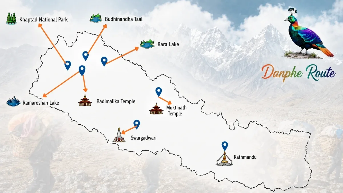
Think of the trail less as a single trek and more as a long connector that links together some of Western Nepal's most underrated spots. Here's a brief look at the Danphe trekking route destinations and what makes each one worth visiting.
Khaptad National Park (Sudurpaschim Province)
- Location: Border of Bajhang, Bajura, Achham, and Doti (Sudurpaschim)
- Altitude: 3,000 m
- Accessibility: Moderately accessible (Drive to Silgadhi, Doti + hike)
- Main Highlight: 22 rolling green alpine meadows (Patans) and the historic Khaptad Baba Ashram.
- Best Season: Spring (March–May) and Autumn (September–November).
- Accommodation: Limited local homestays or basic military barracks contact points; tent camping recommended.
- Wildlife Factor: High-density habitat for the Danphe (Himalayan Monal) and rare medicinal herbs.
The western access point of the Danphe Route in Nepal is Khaptad National Park, the official start of the corridor. The park is spread over four districts, namely Doti, Achham, Bajhang, and Bajura. It is known for its rolling grasslands, dense pine and oak forests, and peaceful natural
environment.
Unlike most trekking destinations in Nepal, which have steep mountain terrain, Khaptad features broad open meadows called "patans" locally. These grasslands explode into wildflowers in spring and summer, creating one of the country’s most scenic highland landscapes.
The park is also spiritually significant as the home of the late Khaptad Baba, a revered Hindu sage who meditated here for decades. His ashram is still one of the most important places of
pilgrimage in the area.
Khaptad National Park Attractions:
- wide alpine meadows and forest
- Khaptad Baba Ashram,
- Rich wildlife and biodiversity
- Lots of birdwatching opportunities.
- Peaceful trekking away from the crowd
Ramaroshan Complex (Achham District)
- Location: Achham District (Sudurpaschim)
- Altitude: 2,500 m to 3,200 m
- Accessibility: Challenging (Rugged jeep drive from Mangalsen + trek)
- Main Highlight: The "Chauri Bagaicha" complex featuring 12 pristine alpine lakes and 18 green lawns.
- Best Season: Autumn (September–November) when the wetland lakes are completely full.
- Accommodation: Strictly camping-only (Zero commercial hotel infrastructure).
- Wildlife Factor: Prime territory for spotting Himalayan Thar and barking deer in wild pine forests.
Ramaroshan of Achham District is one of the least explored destinations along the Danphe Trail of Nepal. This area is often called the “Land of 12 Lakes and 18 Meadows,” and it combines wetlands, grasslands, forests, and mountain scenery into one landscape.
The area remains largely untouched by mass tourism, making it attractive to travelers seeking solitude and authentic rural experiences. The lakes dotted around the region are culturally and religiously important to the local communities.
Ramaroshan Attractions:
- Twelve lakes of natural formation
- Eighteen great meadows
- Pristine natural beauty
- Cultural and spiritual importance
- Good for nature photography
Badimalika Temple (Bajura District)
- Location: Bajura District (Sudurpaschim)
- Altitude: 4,210 m
- Accessibility: Difficult / Strenuous (Multi-day wilderness trek on rugged trails)
- Main Highlight: Endless, emerald-green rolling ridges that look like a giant carpet under Mt. Api and Saipal.
- Best Season: August (for the vibrant cultural pilgrimage) or October–November (for crisp views).
- Accommodation: Strictly camping-only (Trekkers must carry all food, fuel, and tents).
- Wildlife Factor: Famous for vast high-altitude grazing livestock and post-monsoon alpine wildflower blankets.
Badimalika Temple is one of the most important religious destinations in the Khaptad to Muktinath Route. The temple, which is located at an altitude of around 4,200 meters, draws thousands of Hindu pilgrims every year.
The road to Badimalika is as much fun as the destination itself. Trekkers cross giant grasslands, ridgelines, and remote mountain settlements before reaching the holy shrine.
Highlights of Badimalika Temple:
- Major Hindu pilgrimage
- Stunning mountain views
- Himalayan views from the top
- Religious festivals, annual
- Rich cultural history
Budhinanda Lake (Alpine Zone)
- Location: Bajura District (Sudurpaschim)
- Altitude: 4.000 m
- Accessibility: Extremely remote (Rarely trodden paths; requires a mandatory local guide)
- Main Highlight: Deeply isolated, highly sacred glacial lakes hidden right beneath the rocky ridges of Bajura.
- Best Season: Autumn (October–November).
- Accommodation: Strictly camping-only (Complete off-the-grid survival setup required).
- Wildlife Factor: Pristine, untouched high-altitude ecosystem with zero human disturbance.
Budhinanda Lake is one of the most remote destinations in the proposed Danphe Route Destinations network. The lake is in an alpine basin in the high mountains of Bajura District, far from the rugged terrain.
Few visitors make their way here each year, leaving the lake as one of the better-preserved natural attractions of western Nepal. The setting is tranquil and the environment pristine, making it especially attractive to adventure travelers.
Budhinanda Lake Highlights:
- Alpine lake in the remote
- Pristine natural environment
- Spectacular mountain views
- Good camping options
- Low tourist traffic
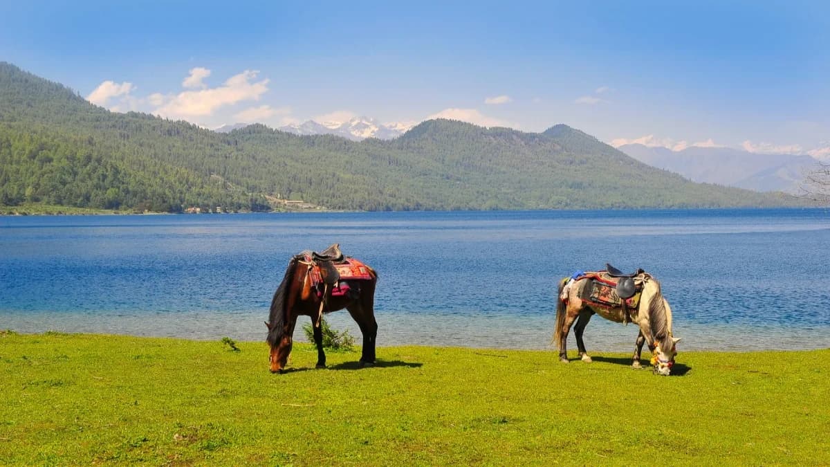
Rara Lake (Karnali Province)
- Location: Mugu District (Karnali)
- Altitude: 2,990 m
- Accessibility: Well accessible (Short domestic flight to Talcha Airstrip or a rugged jeep drive)
- Main Highlight: Nepal’s largest, deepest freshwater lake known for water that shifts shades of blue all day.
- Best Season: Spring (March–May) and Autumn (September–November).
- Accommodation: Developing local infrastructure (Lakeside lodges, permanent tent camps, basic guesthouses).
- Wildlife Factor: Home to the rare Red Panda, Himalayan Black Bear, and three endemic species of snow trout.
Rara Lake is the most popular destination linked by the Danphe Route Trek. It is the largest freshwater lake in Nepal, located in Mugu District in Rara National Park. Deep blue waters, pine forests, and a snow-capped mountain backdrop have earned it the nickname “Queen of Lakes." Many travellers consider Rara one of the most beautiful natural destinations of Nepal.
Rara Lake Highlights:
- Nepal’s biggest lake
- Clear as crystal Blue water
- Wildlife of Rara National Park
- Mountain and forest landscape
- Popular trekking spot
Swargadwari Hilltop (Pyuthan District)
- Location: Pyuthan District (Lumbini)
- Altitude: 2,120 m
- Accessibility: Highly accessible (Paved roads connect directly to the temple base)
- Main Highlight: A deeply revered hilltop Hindu shrine famous for continuous Vedic fire rituals (Akhanda Mahayajna).
- Best Season: Year-round (Pleasant, mild mid-hill climate).
- Accommodation: Fully commercialized (Abundant local dharamsalas, budget hotels, and local eateries).
- Wildlife Factor: Mid-hill bird species and lush pine-covered hilltops.
Swargadwari is a famous pilgrimage site in Pyuthan District. The name means “Gateway to Heaven," and it describes its deep religious significance in the Hindu tradition. Every year thousands of pilgrims come to worship and enjoy the peaceful atmosphere of the hilltop temple complex. The hills around also provide stunning panoramic views of the Himalayan range.
Swargadwari: Highlights:
- Hindu Shrine Important
- Historical religious legacy
- Beautiful hillside setting
- spiritual culture of the traditional
- Views of the mountains
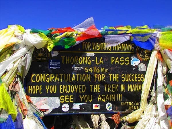
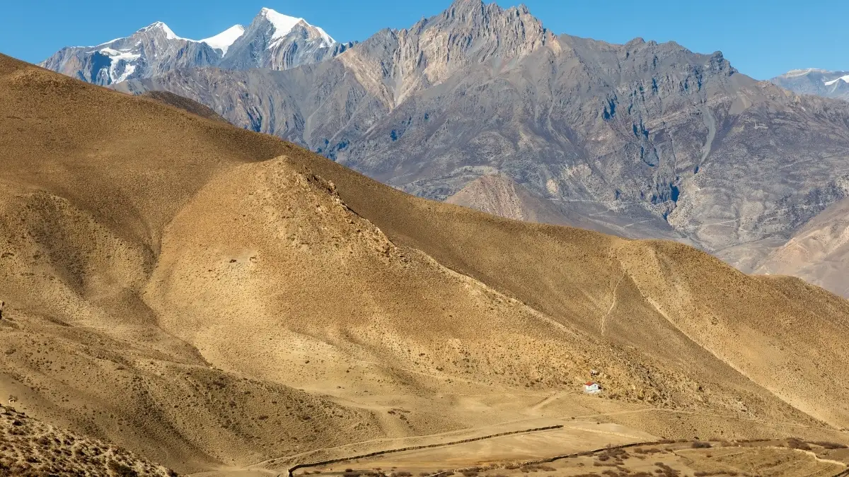
Muktinath Temple (Mustang District)
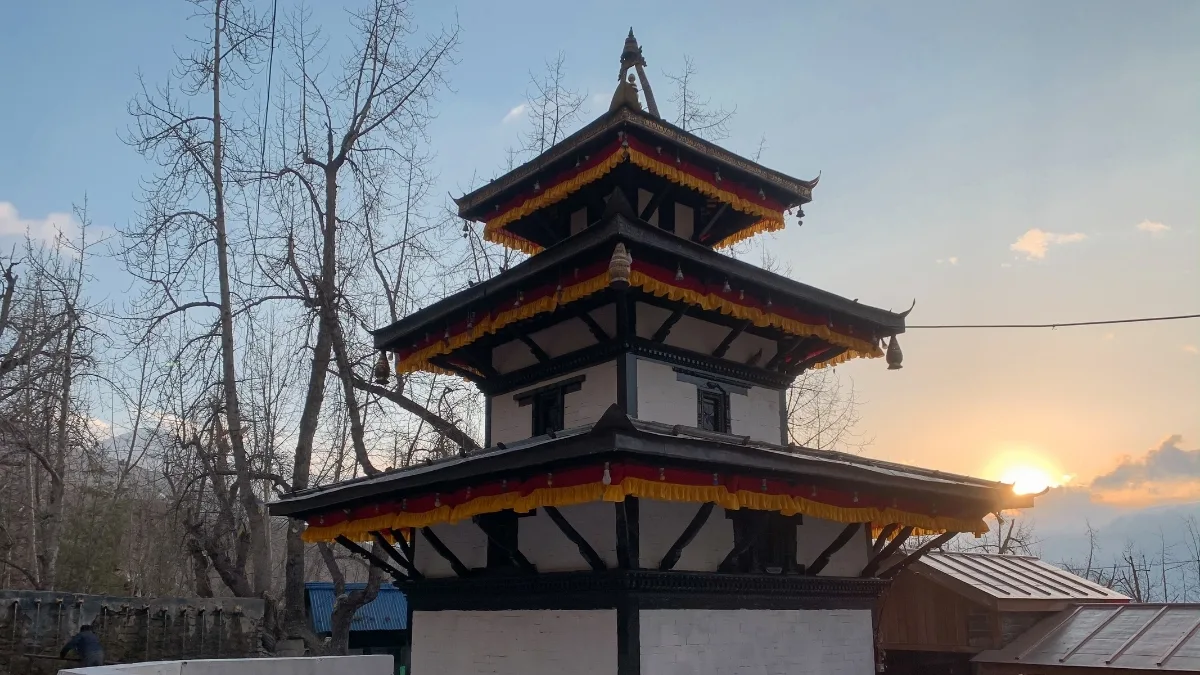
- Location: Mustang District (Gandaki)
- Altitude: 3,800 m
- Accessibility: Fully accessible (Flights to Jomsom, local jeeps, or well-paved roads along the Annapurna Circuit)
- Main Highlight: A world-famous sacred valley of religious harmony featuring 108 eternal waterspouts and a natural gas fire spring.
- Best Season: Spring (March–May) and Autumn (September–November).
- Accommodation: Premium/Fully developed (Luxury teahouses, standard hotels, Wi-Fi, hot showers, and global menus).
- Wildlife Factor: Stark, arid Tibetan-style landscapes; unique fossil stones (Shaligrams) found in the nearby riverbeds.
Muktinath Temple is the easternmost point of Nepal’s Danphe Route. Located in the Mustang District at 3,710 meters, it is one of the holiest pilgrimage sites in the Himalayas.
It is a unique monument of religious harmony, as both Hindus and Buddhists worship the temple. Muktinath is a memorable end to the proposed Danphe Route corridor, surrounded by the dramatic landscapes of the Mustang region.
Muktinath Temple Highlights:
- Sacred place of Hinduism and Buddhism
- 108 fonts of holy water
- Scenery of unique desert mountains
- Main pilgrimage location
- Cultural and spiritual values
Inspired by destinations like Khaptad National Park, Rara Lake, and Muktinath Temple? Contact Nepal Gateway Trekking to create a personalized itinerary that matches your interests, travel style, and available time.
These Danphe route destinations each offer something unique, which is part of what makes this corridor so interesting to follow.
|
Trail Sequence |
Destination |
District & Province |
What Makes It Special |
|
START POINT |
Khaptad National Park |
Doti / Achham / Bajhang / Bajura |
Wide open meadows and old oak and pine forests are very different from the rocky high mountains people usually picture |
|
Mid-Corridor |
Ramaroshan |
Achham District |
Known as the "Land of 12 Lakes and 18 Meadows," peaceful wetlands with deep spiritual roots for locals |
|
Mid-Corridor |
Badimalika Temple |
Bajura District |
A high-altitude pilgrimage site with sweeping views, important for Hindu devotees year-round |
|
Mid-Corridor |
Budhinanda Lake |
Bajura District |
A quiet alpine lake tucked into an isolated mountain basin, barely visited by outsiders |
|
Mid-Corridor |
Rara Lake |
Mugu District |
Nepal's largest lake, ringed by thick pine forest, often called the "Queen of Lakes." |
|
Mid-Corridor |
Swargadwari |
Pyuthan District |
A revered hilltop sanctuary with deep religious history, popular with pilgrims from across the region |
|
END POINT |
Muktinath Temple |
Mustang District |
A sacred site for both Hindus and Buddhists, sitting at the dramatic edge of the Mustang desert landscape |
Where Does the Trail Start and End?
The starting gate is Khaptad National Park in Sudurpaschim Province, and the finish line is all the way over at Muktinath Temple in Mustang. Now, here's the honest part. Walking this whole stretch in one go would take weeks, and the terrain in between isn't exactly forgiving.
So most travelers right now pick a specific section of the Khaptad to Muktinath Route that fits their timeline, rather than trying to do the whole thing in one trip.
Why Nepal Created the Danphe Trekking Route?
The Danphe Trekking Route is more than just a new trekking corridor; it is a long-term development strategy designed to transform how travelers experience the Himalayas.
For decades, international trekking has been heavily concentrated in a handful of iconic areas like Everest and Annapurna, putting severe pressure on local infrastructure and trails.
By introducing this west-to-east strategic belt, the government's eco-tourism framework focuses on three core developmental objectives:
Tourism Diversification beyond Mount Everest and Annapurna
The trekking industry in Nepal has traditionally been heavily dependent on the Everest and Annapurna regions, which draw the vast majority of international trekkers each year. These places are still world-famous, but the high volume of visitors is taxing local infrastructure, trails, and natural resources.
The Danphe Route Project was established as part of Nepal’s wider tourism diversification programme. The government is planning to establish a new corridor for long-distance trekking through western Nepal to encourage visitors to explore less-visited areas and to reduce reliance on a few popular trekking spots.
If successful, a Danphe Trekking Route could eventually provide international visitors with a whole new Himalayan experience, aiding Nepal in expanding its trekking portfolio beyond the country’s traditional hotspots.
Regional Economic Growth
One of the main objectives of Danphe Trekking Route Eco-Tourism is to bring tourism income to the districts that have had very few visitors in the past. Bajura, Mugu, Kalikot, and some other far western districts are endowed with extraordinary natural and cultural attractions but have remained largely outside the mainstream of Nepal’s tourism economy.
As more visitors come, local communities can benefit from jobs such as guiding services, porter work, homestays, transportation, food supply chains, and small tourism-related businesses.
While big infrastructure projects usually require large investments, trekking tourism can bring immediate economic benefits to local communities, helping them to maintain their lifestyles and traditions.
Nature Conservation and Eco-Tourism
The Danphe Route vision is conservation-centric. The project has been designed from the beginning as an eco-tourism project, not as tourism with environmental problems to be solved later.
The proposed corridor cuts through or close to some of Nepal’s most important natural landscapes, including Khaptad National Park, Rara National Park, and the Api Nampa Conservation Area.
These ecosystems provide habitat to a wide variety of wildlife, including Himalayan Monal (Danphe), musk deer, and other species adapted to high altitudes. The Danphe Route ecotourism model promotes responsible travel and community participation to create a sustainable balance between conservation and economic development.
It represents the overarching goal of taking Sustainable Tourism Nepal forward while safeguarding fragile mountain ecosystems for future generations.
Current Status of the Danphe Route Nepal Project
So here's the thing, this project is still very much in motion. A single, fully connected trail with consistent signage and teahouses across every section doesn't exist yet. Local authorities are still working through the mapping and planning stages. But that doesn't mean there's nothing to do right now.
While the full Danphe Route is still under development, many of its key destinations are already accessible. Our trekking team can help you explore these regions through carefully designed trekking and cultural tours.
Is the Danphe Route Trek Open?
No, the continuous, end-to-end Danphe Route is not yet open. Because this mega-trail was just introduced in the government's national budget, it currently exists as an ambitious tourism blueprint rather than a physically completed trail.
There are no unified trail markers, connecting maps, or continuous teahouse networks linking all seven regions together yet. Building the infrastructure to bridge these remote western highlands will take time.
However, you can easily trek the individual segments right now:
- Fully Open & Developed: Rara Lake and Muktinath (Mustang) have excellent lodge infrastructure, clear trails, and are highly accessible.
- Open for Camping Expeditions: Khaptad, Ramaroshan, and Badimalika are completely open to adventure seekers, but you must bring your own tents, food, and a local guide since there are no commercial hotels.
The Verdict: You cannot trek the entire route in one continuous trip yet, but you can absolutely explore its best destinations as separate, independent treks.
How Difficult is the Danphe Route Trek?
Honestly, there's no single answer to this one. The Danphe route difficulty really depends on which part of the corridor you're referring to. Western Nepal isn't exactly one type of terrain, so as you move from section to section, the challenges change quite a bit too.
Some stretches are pretty chill and beginner-friendly, while others will test you, especially if you're not used to high altitude or remote walking with almost zero facilities around.
Here's a rough breakdown of what to expect from each destination:
|
Destination |
Difficulty |
Why It's Like That |
|
Khaptad National Park |
Easy to Moderate |
Gentle, rolling trails through meadows and forest. Probably the friendliest section on the whole Danphe Route Trek. |
|
Ramaroshan |
Moderate |
Hills, lakes, meadows, nothing too brutal, but the area is remote, and you won't find much tourist infrastructure. |
|
Badimalika Temple |
Moderate to Challenging |
Steep climbs, high altitude, and long days on foot. This pilgrimage route earns its name. |
|
Budhinanda Lake |
Challenging |
One of the toughest and most isolated stops. The terrain is rugged, and there are very few facilities. |
|
Rara Lake |
Moderate |
Better roads and trekking routes already exist here, so it's more accessible, though some of the walks are still long. |
|
Swargadwari |
Easy to Moderate |
Village trails and pilgrimage paths make this one feel pretty approachable. |
|
Muktinath Temple |
Moderate |
The altitude and Mustang's dry, windy conditions can be surprising for first-timers. |
What Makes the Full Danphe Route Challenging?
If someone ever manages to walk the entire Khaptad to Muktinath Route as one continuous trail, that person deserves a serious round of applause. Here's why it'd be such a beast:
- The distances between major stops are long, like, really long
- You'd be crossing several high-altitude zones back-to-back
- A lot of the terrain in between is just remote mountain wilderness
- Places to stay and eat are scarce in certain stretches
- Weather can flip on you with almost no warning
Accommodation & Infrastructure Development of Danphe Route
The blueprint for this project includes proper trail marking, emergency shelters along remote stretches, and a network of community-run homestays. Right now though, most of the connecting regions between the major destinations don't have teahouses.
If you're planning to link sections together, you'll likely need a fully self-sufficient camping setup, which means a guide and porter team who know the terrain well.
On the transport side, there's talk of upgrades to gateways like the Talcha Airstrip near Rara and improved regional roads across the Far-West. These upgrades would make a huge difference in how accessible this corridor becomes.
Best Time to Trek the Danphe Route
Timing matters a lot in this part of Nepal, maybe even more than in the more popular regions. Generally, spring (March to May) and autumn (September to November) are the best times for the Danphe Route trek. The weather is more stable, visibility is decent, and the meadows along sections like Khaptad and Ramaroshan are at their greenest.
Winter brings heavy snow to the higher sections, which can make passes near Rara and Mustang difficult or outright impassable. Monsoon season (June to August) is also tricky here, with trails getting muddy and visibility dropping due to clouds and rain.
If you're set on exploring this Western Nepal trekking route, plan around these seasonal patterns to save yourself many headaches.
Not sure which season is best for your trip? Get in touch with Nepal Gateway Trekking for expert advice on weather, trail conditions, and the best trekking destinations in Western Nepal.
Final Thought
The Danphe Trail, Nepal, is an ambitious tourism project that aims to connect some of Western Nepal's most remarkable natural, cultural, and spiritual destinations. From Khaptad National Park and Rara Lake to Muktinath Temple, the route showcases a less-explored side of the Himalayas while supporting local communities and conservation efforts.
As the project continues to develop, it has the potential to become a flagship example of sustainable tourism in Nepal, creating new opportunities for regional growth without compromising the environment.
Whether you're interested in Khaptad National Park, Rara Lake, Muktinath Temple, or other hidden gems of Western Nepal, Nepal Gateway Trekking can help you build a customized trekking experience with expert local support and guidance.
FAQs
What is the Danphe route in Nepal?
The Danphe Route (often spelled Danphe Route) is a government-backed high-altitude eco-tourism corridor designed to connect some of Western Nepal's most beautiful natural, cultural, and spiritual sites into one continuous trail system.
Where does the Danphe Route start and end?
The proposed corridor begins at Khaptad National Park in Far-Western Nepal and runs eastward, ending at the Muktinath Temple complex in Mustang.
Is the entire Danphe Route open for continuous trekking?
Not yet as one seamless trail. The full route is still being mapped and developed. That said, major sections like Khaptad, Rara Lake, and Muktinath are already open and fully accessible for trekkers right now.
What is the difficulty level of the Danphe Route?
Since it passes through less-developed terrain across Western Nepal, the Danphe Route's difficulty ranges from moderate to strenuous, depending on which specific sections you choose to trek.
When is the Best Time for the Danphe Route Trek?
Spring and autumn are your safest bets across most sections, since the trails are drier, visibility is better, and the meadows are at their most scenic.