The Mohare Danda and Khayar Lake Trek Map gives you a proper picture of the whole route before you even lace up your boots. You can actually see where the trek starts, how the trail slowly climbs up to Mohare Danda at about 3,300 meters, and then keeps pushing higher all the way to the sacred Khayar Lake, which sits at around 4,660 meters in the Annapurna region of Nepal. It just makes everything feel more real when you look at it on a map first.
And honestly, it’s not just some simple line showing “start here, end there.” The map points out the direction of the trail, villages like Nangi and Swanta, forest stretches, ridge sections, and that wild high alpine area near Khayar Lake. You can also get a sense of the daily elevation gain. That part matters more than people think because altitude hits differently up there, and you really need to understand how your body might react.
If you’re planning to do Mohare Danda and Khayar Lake trek, take some time to study the trek map beforehand. It helps you roughly calculate walking hours, mentally prepare for steep climbs, and understand how the whole landscape is laid out. It’s basically your safety backup. When you know what’s ahead, you walk with way more confidence.
Where Is Mohare Danda and Khayar Lake Located?
- Duration: 13 Days
- Difficulty Level: Moderate
- Maximum Altitude: 4,827m (Khayar Lake)
- Best Season: Spring (March-May) & Autumn (September-November)
- Start/End Point: Kathmandu / Pokhara
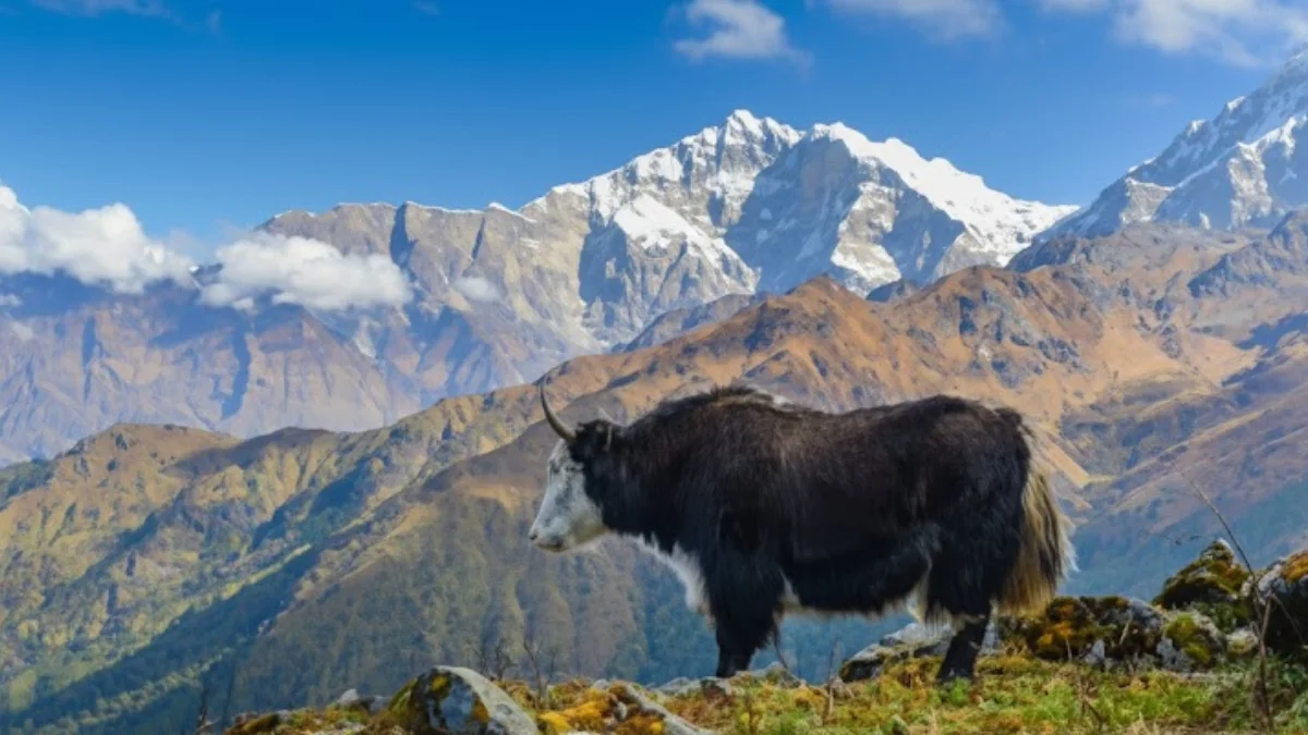
Mohare Danda and Khayar Lake are in the Annapurna region of north-central Nepal. Administratively, they’re part of Myagdi District in Gandaki Province.
The trekking area lies between the Annapurna and Dhaulagiri ranges, west of the Ghorepani trail and north of Beni. Mohare Danda sits above Nangi village on a high ridge, while Khayar Lake is further north in the alpine zone beneath Annapurna South.
Most trekkers access this route from Pokhara, which serves as the main gateway to this part of Annapurna. From there, you drive toward the Myagdi area to reach the starting point of the trail. Because this route climbs quickly from local valleys into high alpine fields, make sure you choose the best time for Mohare Danda and Khayar Lake Trek clear mountain views.
For a smooth and guided experience, Nepal Gateway Trekking is a reliable option for exploring Mohare Danda and Khayar Lake.
Understanding the Altitude Chart
The Altitude Chart on the Mohare Danda and Khayar Lake Trek Map shows exactly how the trek rises and falls. It’s really useful for figuring out how your body might cope with the altitude along the way.
The first few days are a steady climb from Pokhara (820m) up to Mohare Danda (3,315m). It’s a gradual rise, which gives your body time to adjust and also lets you enjoy those ridge views without feeling completely wiped out.
After Mohare Danda, the trail drops a bit down to Swanta (2,270m), giving you a breather before the big push. The highest point comes on Day 8 at Khayar Lake (4,827m). Hitting that sacred alpine lake is honestly the highlight, not just because of the spiritual vibe, but the views of the Himalayas are unreal.
From there, the chart shows a slow descent through the foothills, past small villages and forests, until you’re back at lower altitudes by the end of the trek.
Going over this altitude info on the Mohare Danda and Khayar Lake Trek Map is really important. It helps you plan, stay safe, and be ready for the high-altitude stretches without surprises.
Route Overview: The Journey from Kathmandu to the High Altitudes
The trek kicks off in Kathmandu at 1,310 meters, where most international travelers land. From there, you head west by road to Pokhara at 820 meters, which is basically the main gateway for trekking in the Annapurna region.
From Pokhara, the drive continues toward Beni, the Myagdi district headquarters. The trail officially starts after passing Galeshwor, where you leave the highway behind and step onto the community-managed footpaths. That’s when the trek really begins.
The path slowly climbs through terraced farmland, mixed forests, and Magar villages like Banskharka and Nangi. Eventually, you reach Mohare Danda at 3,315 meters, a famous ridge viewpoint with some amazing scenery. From there, the trail pushes north toward Khopra Danda at 4,020 meters, and finally up to Khayar Lake at 4,827 meters, the highest and most remote point of the trek.
After soaking in the lake views, the trail heads down through alpine and forested areas toward Ghandruk, reconnecting with the more popular Annapurna trails before making your way back to Pokhara.
Daily Itinerary Breakdown - 13 Days
Based on the Mohare Danda and Khayar Lake Trek Map, the trek is split into 13 stages to help with acclimatization and make sure you actually enjoy the journey:
- Day 1: Arrival in Kathmandu (1,310m)
- Day 2: Drive from Kathmandu to Pokhara (820m)
- Day 3: Drive to Galeshwor and trek to Banskharka (1,525m)
- Day 4: Trek to Nangi Village (2,250m) – known for community organic farming
- Day 5: Trek to Mohare Danda (3,315m) – a stunning spot for sunrise and sunset views
- Day 6: Trek to Swanta (2,270m)
- Day 7: Trek to Khopra Danda (4,020m) – jaw-dropping ridge views of Dhaulagiri
- Day 8: Day hike to the sacred Khayar Lake (4,827m) and back to Khopra Danda
- Day 9: Trek down to Dobato (3,550m) via Bayeli (3,432m)
- Day 10: Trek to the charming Gurung village of Ghandruk (1,950m) via Tadapani
- Day 11: Trek to Birethanti/Nayapul and drive back to Pokhara (820m)
- Day 12: Drive from Pokhara back to Kathmandu (1,310m)
- Day 13: Final Departure
This breakdown really helps you visualize each day, figure out distances, and pace yourself according to the Mohare Danda and Khayar Lake Trek Map.
Key Landmarks of the Mohare Danda & Khayar Lake Community Trek
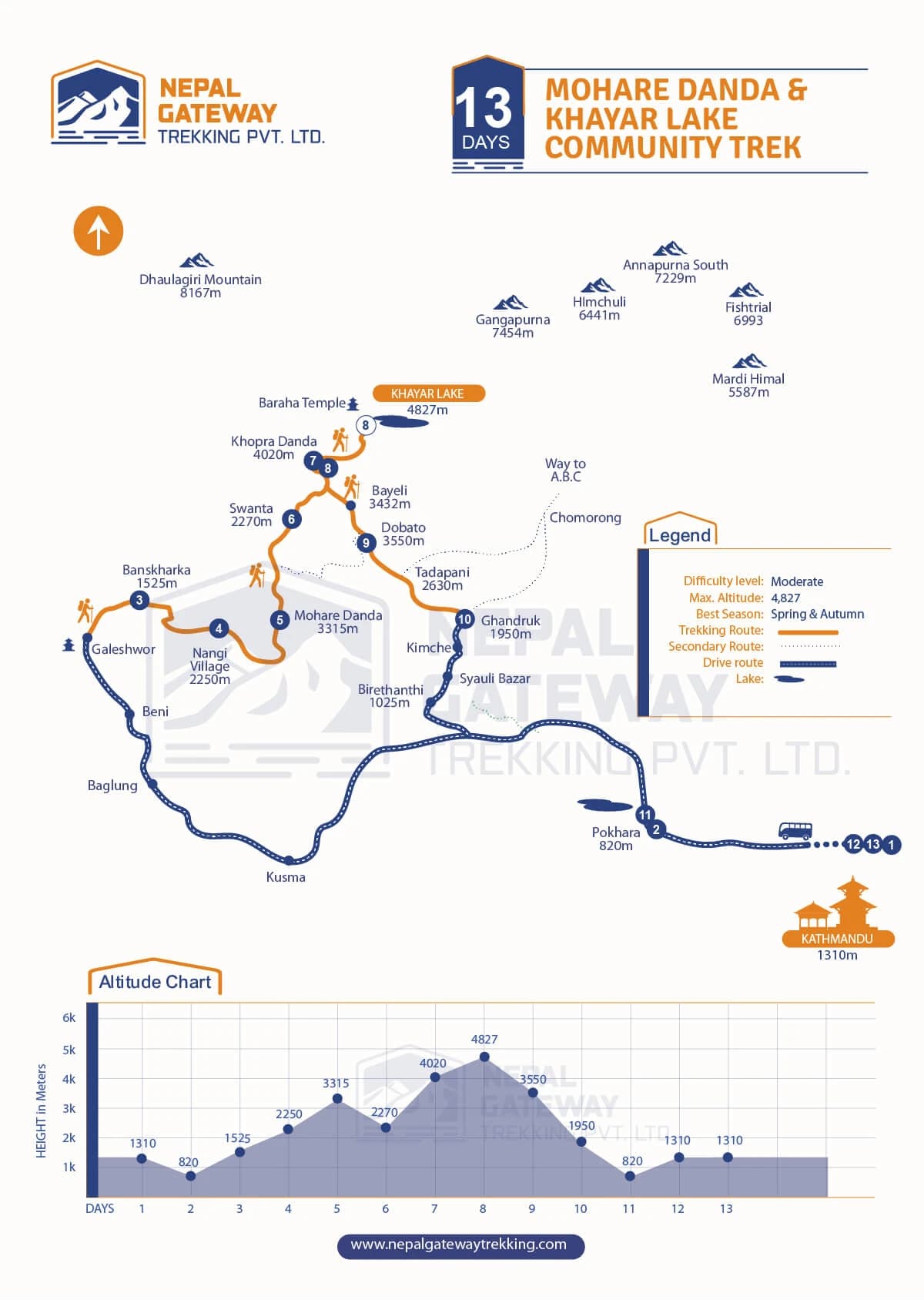
The Mohare Danda and Khayar Lake Trek Map shows all the important spots along the route, where the trail starts, climbs, and hits the best viewpoints. Here’s a closer look at the main landmarks on this community-based trek.
Gateway Cities & Drive Route
Every trek starts with getting closer to the mountains:
- Kathmandu (1,310m): Nepal’s capital and where most travelers begin.
- Pokhara (820m): The lakeside city that’s the main gateway to the Annapurna region.
- Beni, Baglung, Kusma: Towns you pass through that slowly shift you from city roads to mountain trails.
- Birethanti (1,025m), Syauli Bazar, Kimche: Key spots on the way back toward Pokhara.
These towns mark the change from urban life to the Himalayan wilderness. Once the road ends, the real trekking adventure begins.
You might be interested about Sinuwa which is also gateway to Annapurna region.
Lower Villages & Cultural Stops
The trek kicks off by passing through some really peaceful hills and local villages, which is a nice way to get a feel for traditional life in the Annapurna region.
- Galeshwor – A quiet little stop before the trail starts climbing properly.
- Banskharka (1,525m) – You’ll pass lush farmland and forested paths here. It’s simple, but the scenery really grows on you.
- Nangi Village (2,250m) – This place is known for community-based tourism. There are cozy lodges run by local families, so you get that authentic experience, hanging out with locals and seeing their daily life.
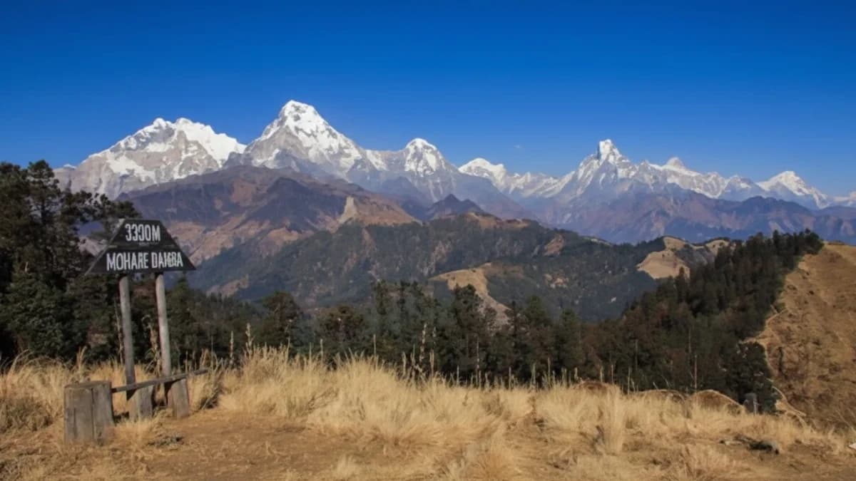
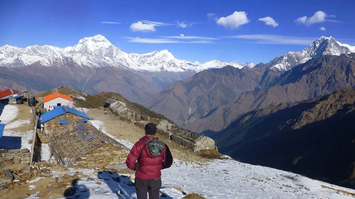
Mohare Danda – The First Big Viewpoint (3,315m)
Mohare Danda is one of the big landmarks on the Mohare Danda and Khayar Lake Trek Map. People go there for the sunrise views, and honestly, the ridge gives you insane panoramas of snow-capped peaks glowing in the morning light.
From this point, you can spot Annapurna South, Dhaulagiri, Nilgiri, Machhapuchhre, and other major Himalayan summits. The view just opens up in every direction. It’s wide, peaceful, and kind of gives you a real taste of what high-altitude trekking is all about.
High Ridge & Alpine Section
After Mohare Danda, the trail heads into open ridges and higher alpine terrain:
- Swanta (2,270m) – A quiet village tucked into forested slopes. A nice spot to catch your breath and take in the scenery.
- Khopra Danda (4,020m) – This ridge is dramatic, with wide Himalayan views. It’s way less crowded than the Annapurna Base Camp trails, so it feels wild and untouched.
Khayar Lake – The Highest Point (4,827m)
The trek’s crown jewel, Khayar Lake, sits beneath Annapurna South (7,229m). It’s the highest point marked on the Mohare Danda and Khayar Lake Trek Map.
The climb can be tough because of the thin air, but getting there is so worth it. The calm, the views, and that feeling of actually reaching the top, there’s nothing quite like it.
Return Trail Highlights
Heading down, the trail has its own little gems along the way:
- Bayeli (3,432m) and Dobato (3,550m) – These ridges have views that make you stop more than once. Honestly, you’ll just want to take it all in.
- Tadapani (2,630m) – A calm forested stretch with rhododendron and pine trees. Walking here feels refreshing after the higher climbs.
- Ghandruk (1,950m) – A traditional Gurung village with stone houses and stunning mountain views. It’s a chill spot to rest before heading back to Pokhara.
The Mohare Danda and Khayar Lake Trek Map also shows a little path labeled “Way to A.B.C,” which is handy if you feel like extending your trek toward Annapurna Base Camp.
Major Peaks Marked on the Map
The Mohare Danda and Khayar Lake Trek Map also points out the big Himalayan peaks nearby:
- Dhaulagiri (8,167m)
- Annapurna South (7,229m)
- Gangapurna (7,454m)
- Himchuli (6,441m)
- Machhapuchhre (6,993m)
- Mardi Himal (5,587m)
These snow-covered peaks are like a constant backdrop. Every step you take, they remind you why this hidden trail is one of Nepal’s most rewarding community-based treks.
Why You Need a Proper Trek Map for This Route?
If you’re thinking about this community-based trek, a good Mohare Danda and Khayar Lake Trek Map is honestly a must. Here’s why:
- Remote Sections: Large parts of the trail go through isolated ridges and forests. There aren’t many facilities around, so getting a map helps you stay on track.
- Fewer Trekkers: Unlike Annapurna Base Camp or Ghorepani Trek, this trail doesn’t see tons of people. Getting lost is a real possibility if you’re not careful.
- Limited Signage: Some sections barely have trail markers. A detailed map makes navigation way easier.
- Safety and Navigation: The map shows daily routes, elevation changes, and connecting trails. It’s super useful for planning rest stops, overnight stays, and managing altitude acclimatization.
Why Follow This Map?
The Mohare Danda and Khayar Lake Trek Map is made for this exact community trek. Unlike the commercial Annapurna trails, it highlights secondary routes that support local schools and community lodges. Following it means you’ll stay on the authentic path, avoid crowds, and really experience the culture in villages like Nangi and Swanta.
Ready to explore the hidden ridges and sacred lakes of the Annapurnas? Grab the Mohare Danda and Khayar Lake Trek Map and start planning your adventure with Nepal Gateway Trekking today.
Alternative Routes & Extensions on Map
The Mohare Danda and Khayar Lake Trek Map isn’t just one straight path. It actually shows some route variations and connecting trails, which is great if you want a bit of flexibility.
Secondary Trekking Route
On the map, you’ll notice a lighter line that marks a secondary route. It’s basically an alternative trail running alongside the main orange trekking route. You’ll see this secondary path around the higher sections near:
- Khopra Danda
- Khayar Lake
So depending on things like weather, time, or your personal plan, you can take slight route variations without straying too far from the main trek.
Connection to Annapurna Base Camp (A.B.C)
The map also has a marked path labeled “Way to A.B.C”. This links to the Annapurna Base Camp route. From spots like Dobato and Tadapani, you can connect to the bigger Annapurna trail network instead of just heading back the way you came.
In simple terms, this trek isn’t a dead-end. The map shows ways to:
- Extend your journey toward Annapurna Base Camp
- Customize your route
- Have flexible descent options
Thanks to these marked alternatives, the Mohare Danda and Khayar Lake Trek Map gives you a clear main route but also the freedom to adjust or extend your trek depending on how much time you have or what kind of adventure you’re after.
Final Thoughts
The Mohare Danda and Khayar Lake Trek isn’t just another trek, it’s a proper journey through remote ridges, quiet villages, and sacred alpine spots. Having a Mohare Danda and Khayar Lake Trek Map in hand makes sure you catch all the highlights safely, from the sunrise views at Mohare Danda to the peaceful beauty of Khayar Lake.
This community-based route is a nice alternative to the busy Annapurna trails. You get to connect with local culture, support village lodges, and enjoy the calm majesty of the Himalayas. Knowing the landmarks, keeping an eye on altitude changes, and planning ahead just make the whole trek way more enjoyable.
If you’re excited to wander hidden trails, experience Himalayan culture up close, and take in some of Nepal’s most jaw-dropping landscapes, reach out to Nepal Gateway Trekking and kick off your Mohare Danda and Khayar Lake Trek Map adventure today.
Frequently Asked Question
How difficult is the Mohare Danda and Khayar Lake trek
It’s generally a moderate trek. You’ll start with gradual climbs, which give your body time to adjust, but there are some steeper ridge sections near Mohare Danda and Khopra Danda. It’s doable if you’re reasonably fit, but the higher sections can be a bit challenging.
How long does the Mohare Danda and Khayar Lake trek take?
The whole trek usually takes around 13 days, including the drive from Pokhara and the return to Kathmandu. Most days involve 4 to 7 hours of walking. Some sections, like from Nangi to Mohare Danda, are shorter and easier, while the days heading up to Khayar Lake take longer because of the bigger climbs.
What is the altitude of Khayar Lake?
Khayar Lake is the highest point on this trek at 4,827 meters. It sits right below Annapurna South and is a sacred alpine lake. Getting there is a real reward, you’ll have panoramic Himalayan views and a quiet, peaceful vibe that feels almost spiritual.
Is a guide mandatory on the Mohare Danda and Khayar Lake trek?
You can follow the Mohare Danda and Khayar Lake Trek Map on your own, but honestly, having a guide makes life a lot easier. Some parts of the trail go through remote ridges and forests with very few signs. A guide helps you navigate safely, shares local culture, and can help arrange overnight stays in community lodges.
Can beginners do the Mohare Danda and Khayar Lake trek?
Yes! Beginners can manage this trek as long as you’re reasonably fit and take it slow. The Mohare Danda Khayar Lake trekking route map shows gradual climbs on most days, which makes acclimatization easier. Just know that the sections to Mohare Danda and Khayar Lake are steep, so pacing yourself is key.
What makes the Mohare Danda and Khayar Lake trek different from other Annapurna treks?
This trek is less crowded and community-based, unlike Annapurna Base Camp or Ghorepani. Using the Mohare Danda to Khayar Lake trail map, you’ll pass through villages like Nangi and Swanta, stay in local lodges, and really get a feel for authentic Himalayan culture. Plus, the high ridges and alpine scenery are absolutely stunning.